
The next snowstorm to impact the eastern U.S. is forming, but earlier model runs suggesting a blizzard appear to be a bomb, having busted on the idea that a storm would intensify and move up the coast while it appears likely the system will simply head out to sea.
Earlier runs of both the American GFS and European ECMWF forecast model indicated there could be a potent blizzard impacting parts of the east coast this weekend. As recently as yesterday, the American model continued to depict not only a blizzard in its outlook, but a blizzard bomb. However, it appears the model forecast is bombing, not the storm, with a weaker system expected to move east out to sea without explosively intensifying and heading up the coast as initially modeled.
The GFS and ECMWF are among many computer models meteorologists use to assist in weather forecasting. While meteorologists have many tools at their disposal to create weather forecasts, two primary global forecast models they do use are the ECMWF from Europe and the GFS from the United States. While the models share a lot of the same initial data, they differ with how they digest that data and compute possible outcomes. One is better than the other in some scenarios, while the opposite is true in others. No model is “right” all the time. Beyond the ECMWF and GFS models, there are numerous other models from other countries, other academic institutions, and private industry that are also considered when making a forecast.
While a blizzard bomb is unlikely to occur, a significant winter storm remains on track to bring a wintry mix of snow, sleet, and freezing rain to a large portion of the Southern and Eastern U.S to round out the work week. The developing storm is set to begin late tonight across portions of West Texas before expanding north and eastward across the Red River Valley, southern Ozarks, the Mid-South, and the Tennessee Valley Thursday into Friday.
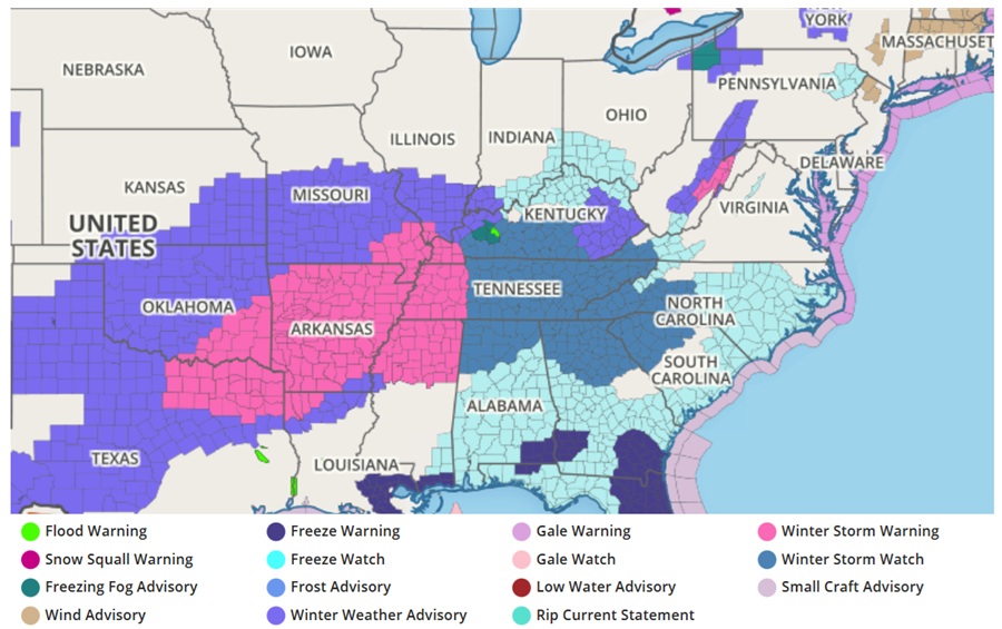
A large swath of heavy snow is expected to dangerously impact travel from southeast Oklahoma through much of Tennessee where accumulations have the potential to exceed 6″. Farther south, snow will transition from snow, to sleet, to freezing rain as warmer air aloft overspreads sub-freezing temperatures at the surface. The freezing rain will turn surfaces from roads, to sidewalks, to trees and power lines icy, leading to hazardous travel and the concern for downed tree branches and power outages from portions of Texas, Arkansas, and parts of the Southeast.
In the Mid Atlantic, Arctic high pressure well to its west will gradually build into the area through the end of the week and also weaken. That low tracking across the southeast is forecast to exit off the Mid-Atlantic coast during Saturday. With the southern and northern stream shortwaves failing to phase or phasing too late to bring significant snow to the region, there won’t be much snowfall in the Mid Atlantic.
The storm track looks to remain far enough south and east to limit significant accumulations in the densely populated I-95 area from DC to New York City, though the precipitation shield should get up into the region for at least a period Friday Night into Saturday morning. An abundance of cold air in place ahead of the system and favorable timing of the system moving through will result in snow as the precipitation type.
Snowfall amounts there will generally be around a coating to an inch from Philadelphia on north, with around 1-2″ around and south of the Philadelphia metro area. A few localized spots, mainly in southern Delaware and the lower Eastern Shore could get above 2 inches. A swath of 3-6″ is possible over portions of Delaware and southern Maryland.
Precipitation is expected to be off the coast by Saturday afternoon, though winds will pick up behind the departing low as a tight gradient sets up with the incoming high on the way.
