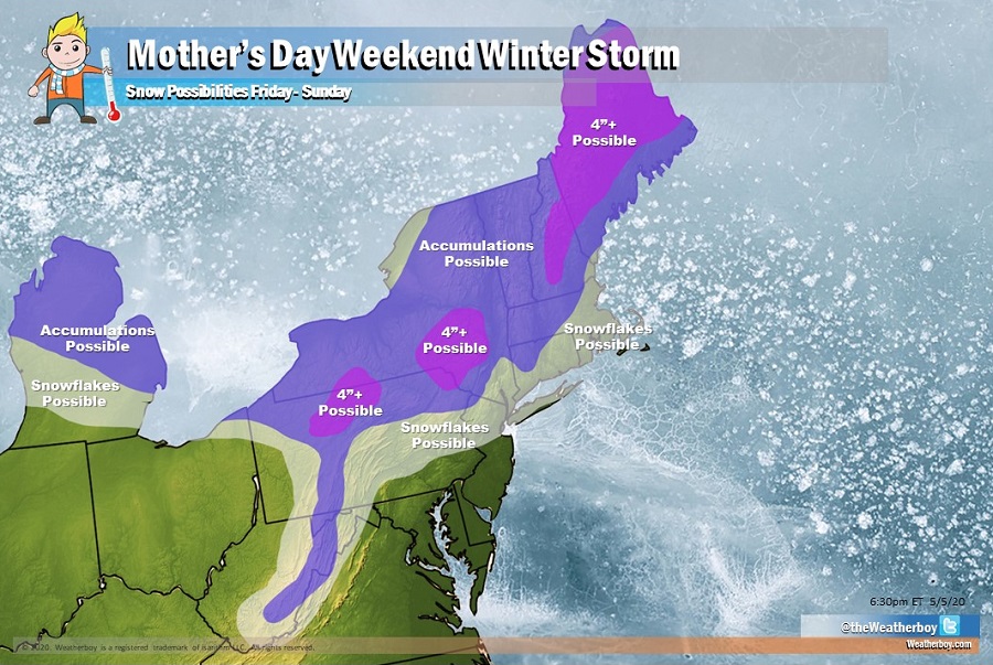
An unseasonably cold weather pattern and a potent area of low pressure will conspire together to create the possibility of a winter storm just in time for Mother’s Day Weekend. While snowflakes may fly in places like southern Michigan, central West Virginia, central Pennsylvania, and even New York City and Boston, accumulating snow is also a possibility for northern Michigan and the higher elevations of the northeast. There’s even a chance that 4″ or more could accumulate in portions of Pennsylvania, New York, New Hampshire, and Maine, which could threaten budding and blooming trees, plants, and flowers.
Over the next several days, different weather ingredients will sort themselves out ahead of the weekend winter storm threat. A surface low currently over the Mid-South will move towards the southern Mid-Atlantic coast by tomorrow morning. This low will then lift north-northeast off the New England coast by Thursday night, bringing colder air from southern Canada south as it moves by. Another surface low will move from the Ohio Valley Friday morning to the Canadian Maritimes on Saturday, with a strong cold-frontal passage through the Northeast late Friday. This stronger system on Friday will tap into even colder air, helping produce a snow/rain mix or a cold rain for many. In the higher elevations of the northeast, periods of plain snow can fall, and in some areas, some of that falling snow could accumulate to 4″ or more.
Snow in early May is rare but not impossible. According to weather records, even New York City saw flurries on May 9 in 1977. On that same day, High Point, New Jersey saw a heavy, wet snow total of 10″. That storm, known as the “Mother’s Day Blizzard”, dropped 12.7″ in Worcester, Massachusetts, while 7.5″ fell in Providence, Rhode Island. While cities like New York City, Providence, and Boston could see snow flakes fly at times with this weekend’s system, accumulating snow should remain north and west of these cities. Conditions could also be ripe for graupel to fall in central Pennsylvania, central New Jersey, and Long Island.
The amounts and locations of measurable snow will be determined by a variety of factors not yet etched in stone. People in the northeast should continue to monitor evolving forecasts and keep an eye out for any winter weather advisories that could be issued by the National Weather Service.
Conditions will be colder than normal and widespread frost and freeze conditions could persist through Monday morning in parts of the northeast. Farmers and gardeners are cautioned to be ready to protect any plantings from unusually cold conditions. The same is true for outdoor plumbing: unprotected hose bibs and irrigation lines could freeze, creating some damage if not properly dealt with prior to sub-freezing temperatures.
By Monday into Tuesday, temperatures will warm in the eastern United States, but conditions will still remain below normal climatological temperature levels.
