With the peak of the Central Pacific and Atlantic Hurricane Seasons arriving, so to is an increase in storm activity in both basins. After a lull in activity where only Hawaii was seeing action, it appears the threats to future US strikes is increasing. While Gordon is forecast to make landfall on the central Gulf coast later today, meteorologists are also tracking Norman and Olivia in the Pacific and Florence in the Atlantic. There’s also a good chance that an additional tropical cyclone will form in each basin above and beyond these named storms.

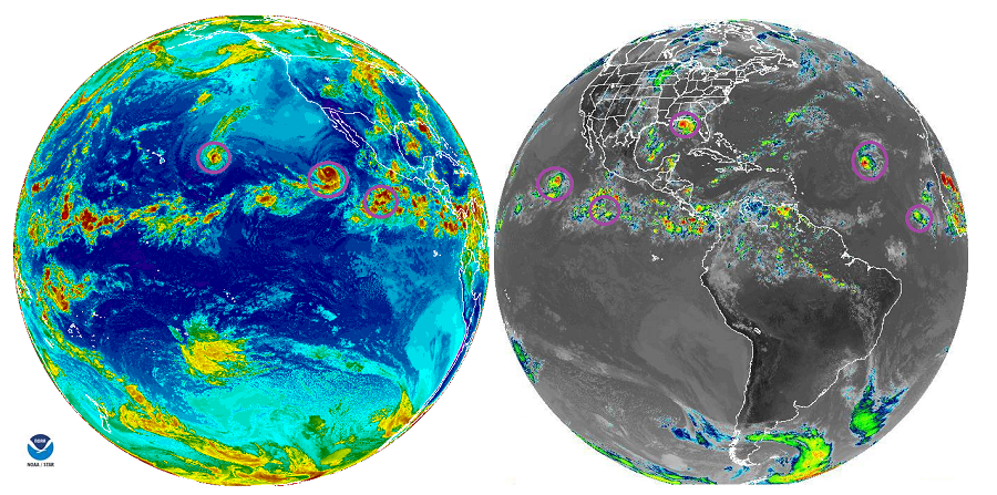
Beyond Gordon, the Atlantic Basin is dealing with the third hurricane of the season, Florence.Recent satellite imagery indicates that Florence has continued to intensify during the past few hours, and maximum sustained winds have increased to 85 mph. While most models suggest the storm will stay at sea, there are some possible tracks that would involve the U.S. East Coast. As such, residents from Florida to Maine should continue to monitor this system should a more westward track to the U.S. East Coast materialize.
The National Hurricane Center expects another system to form in the Atlantic too. A broad low pressure system located a few hundred miles south of the Cabo Verde Islands is forecast to move slowly westward to west-northwestward across the eastern tropical Atlantic for the next several days. According to the National Hurricane Center, environmental conditions are expected to gradually become more conducive for development, and a tropical depression is likely to form by late this week or this weekend. Currently, the National Hurricane Center believes there’s an 80% chance that this formation will occur within the next 5 days. Computer forecast guidance suggests this disturbance has the potential to become the next named system in the basin. If it becomes a Tropical Storm, it would be named Helene.
In the Pacific, Hurricane Norman is expected to pass north and east of Hawaii, sparing it from impacts that were seen by Hurricane Lane last month. While no direct impacts are expected, rough surf on north facing shores could be generated as the storm passes by. Deep moisture around the tropical cyclone could also reach Hawaii and Maui counties, enhancing typical rain showers there.

Hurricane Olivia continues to strengthen and could be a threat to Hawaii next week. Maximum sustained winds are near 105 mph with higher gusts. Additional strengthening is expected today, and Olivia could become a major hurricane, joining Hector, Lane, and Norman with such an intensity. However, a gradual weakening is expected beginning late Wednesday or Wednesday night. Nevertheless, even as a Tropical Storm, Olivia could bring gusty winds and heavy rains to portions of Hawaii if it maintains its westward movement over time. While there is no threat to Hawaii and will be no threat to Hawaii over the next week, people there should review their Hurricane Action Plan and make sure their hurricane supplies are re-stocked after Hurricane Lane.
As with the Atlantic, the Pacific basin appears to be brewing yet another storm where Olivia and the others formed west of Mexico. According to the National Hurricane Center, a broad area of low pressure is likely to form well south of the southwestern coast of Mexico in a couple of days. Environmental conditions appear conducive for gradual development of this system later this week while it moves west-northwestward.
