• Skip to primary navigation
  • Skip to main content
  • Skip to primary sidebar

Weatherboy

Weatherboy Weather News, Maps, RADAR, Satellite, and Forecasts.

  • Local
  • Earth Science News
  • RADAR
  • Current Warnings
  • Satellite
  • Current Maps
  • Forecast Maps
  • Video

National Hurricane Center Monitoring Far Atlantic

by Weatherboy Team Meteorologist - July 10, 2017

Today's 5-day Tropical Weather Outlook from the National Hurricane Center shows an area of concern in the far Atlantic.
Today’s 5-day Tropical Weather Outlook from the National Hurricane Center shows an area of concern in the far Atlantic.  Map: NHC

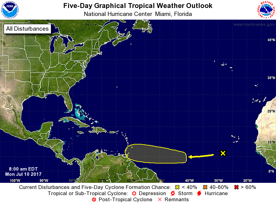
The National Hurricane Center (NHC) is monitoring an area of disturbed weather in the far Atlantic this morning. In their latest Tropical Weather Outlook, the NHC says organized showers and thunderstorms located several hundred miles southwest of the Cabo Verde Islands are associated with a tropical wave. Some gradual development is possible through the week while this system moves westward at about 20 mph across the tropical Atlantic Ocean. Any formation will be slow though; the National Hurricane Center believes there’s no chance a tropical cyclone will form here over the next 48 hours and believes there’s a low chance , just 20%, that a tropical cyclone will form over the next 5 days.


Latest satellite map shows what's left of Tropical Depression #4 north and east of Puerto Rico.  Image: NOAA
Latest satellite map shows what’s left of Tropical Depression #4 north and east of Puerto Rico. Image: NOAA

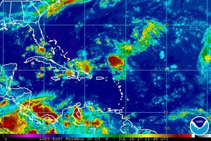
While the National Hurricane Center is keeping an eye on that system, eyes are also on the remnants of Tropical Depression #4 as it moves closer to the Bahamas and the southeastern United States. While no tropical cyclone formation is expected here, the area of moisture associated with this system will enhance rain shower and thunderstorm activity over the Bahamas and the southeastern US later this week.

Experts believe this Atlantic Hurricane Season, which runs through to the end of November, will be a busy one.  Dr. Phil Klotzbach and the experts at Colorado State University updated their seasonal outlook again on July 5, showing a much more active than normal season expected. The National Oceanic and Atmospheric Administration  (NOAA) also released their own forecast which shows this hurricane season to be likely more active than others.
Satellite images, forecast models, and the latest advisories for tropical cyclones anywhere near North America can be found on our Hurricanes & Tropical Weather section of this website.

Primary Sidebar

Sponsored Ad

Search

Latest News

  • Friday Smoke Forecast Looks Bad for Philadelphia, Baltimore, and Washington, DC
  • NOAA Announces the Official Arrival of El Nino
  • USGS Raises Volcano Alert Level to WARNING as Kilauea Volcano in Hawaii Erupts
  • Smoke Creating Very Hazardous Air Travel Conditions Around Philadelphia, Newark, and New York City Airports
  • Smoking 1/2 Pack of Cigarettes Healthier than Breathing in New York City’s Smoky Air Today; Same is True in Pennsylvania, New Jersey, and Other States
  • Smoke from Canadian Fires to Become More Thick in New Jersey, Pennsylvania, Connecticut, Rhode Island, and Massachusetts on Wednesday
  • Hurricane Center Monitoring Disturbance in Northeast Atlantic Ocean
  • USGS Raises Alert Level and Aviation Color Code for Volcano: ADVISORY / YELLOW
About | Careers | Contact | Contests
Terms | Privacy | Ad Choices
Weatherboy is a (R) Registered Trademark of isarithm LLC, All Rights Reserved.
All content herein is Copyright by Isarithm LLC 1997-2022