Nestor made landfall a short time ago on St. Vincent Island on Florida’s Gulf coast. While the storm has lost tropical storm structure, it is still considered a potent post-tropical cyclone that brings with it numerous weather hazards.
With the storm on land, the Tropical Storm Warning that was in effect has been discontinued west of the Ochlockonee River, Florida, and south of the Suwanee River, Florida. Additionally, all Storm Surge Warnings have been discontinued. However, a Tropical Storm Warning remains in effect for portions of Florida from the Ochlockonee River to the Suwanee River. A Tropical Storm Warning means that tropical storm conditions are occurring somewhere within the warning area now.
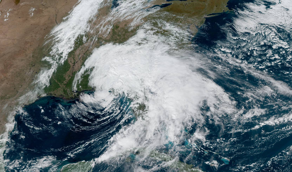
Satellite imagery, NOAA Doppler weather radar data, and surface observations indicate that the center of Post-Tropical Cyclone Nestor was located near latitude 29.7 North, longitude 85.1 West. The post-tropical cyclone is accelerating toward the east-northeast near 23 mph and this motion is expected to continue this afternoon, followed by a motion toward the northeast by tonight and early Sunday. On the forecast track from the National Hurricane Center, Post-Tropical Cyclone Nestor will move farther inland over the Florida Panhandle this afternoon, and will then move across portions of the southeastern United States later tonight and Sunday. The cyclone is expected to move offshore of the coast of North Carolina into the western Atlantic by late Sunday. Doppler radar data and surface observations indicate that maximum sustained winds have decreased to near 45 mph with higher gusts. Some additional slight weakening is expected now that Nestor has moved inland.
Tropical-storm-force winds extend outward up to 185 miles from the center, mainly to the east of the center over Apalachee Bay and also off the Georgia coast. Offshore buoys and coastal marine observing stations along the coast of west-central Florida, including the mouth of Tampa Bay, have recently been reporting tropical-storm-force wind gusts to 40 mph. The minimum central pressure based on nearby surface observations is estimated to be 999 mb or 29.50″.
With winds diminishing, storm surge levels will continue to subside today and tonight along the Gulf coast of Florida.While tropical storm-force wind conditions are expected within the warning area through this afternoon, the warning will likely be discontinued later this afternoon. However, gale-force winds are expected to begin along portions of the Atlantic coast of the southeastern United States later today and tonight.
While the system has been redefined as a post-tropical cyclone from a tropical storm, Nestor is still expected to produce total rainfall accumulations of 2 to 4 inches this weekend across portions of the southeast United States, with isolated maximum amounts of 8 inches. These rainfall amounts could create flooding conditions. The National Weather Service reminds people to never drive through flood waters with the catchphrase, “turn around, don’t drown.”
As Nestor moves north and east, a tornado threat will continue. A few tornadoes are possible through this afternoon over east-central Florida, and this afternoon and tonight over coastal areas of Georgia and the Carolinas. There have already been reports of damage from tornadoes in Florida. The Cape Coral Police Department said in a statement that about dozen homes were damaged earlier this morning by a possible tornado, some severely. No injuries were reported. The Polk County Sheriff’s Office said a tornado damaged about a dozen homes and a school near Lakeland late Friday. No serious injuries were reported there either.
