• Skip to primary navigation
  • Skip to main content
  • Skip to primary sidebar

Weatherboy

Weatherboy Weather News, Maps, RADAR, Satellite, and Forecasts.

  • Local
  • Earth Science News
  • RADAR
  • Current Warnings
  • Satellite
  • Current Maps
  • Forecast Maps
  • Video

New Atlantic Tropical Threat

by Weatherboy Team Meteorologist - July 3, 2017

Circled area reflects where development of a tropical cyclone is likely this week. Satellite Image: NOAA

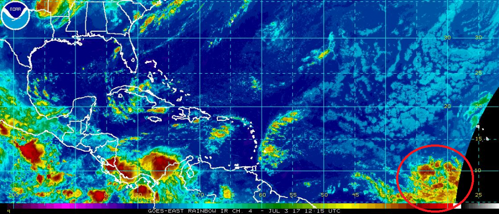
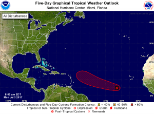
Meteorologists at the National Hurricane Center (NHC) have been tracking an area of disturbed weather in the far Atlantic for signs of development; they now believe there is a high chance that a tropical cyclone will form here this week.  A nearly stationary broad area of low pressure located about 650 miles west-southwest of the Cabo Verde Islands continues to produce disorganized showers and thunderstorms.  According to the experts at the NHC, environmental conditions are expected to become more conducive for development and a tropical depression could form later this week. The disturbance is expected to begin moving west-northwestward in a day or so, and it should continue moving in that direction through the remainder of the week.


The NHC shows the area where a tropical cyclone may form and travel to over the next 5 days. Map: NHC

Computer forecast guidance that meteorologists use to aid in their forecasts suggest this storm will move closer to the US east coast over time, possibly being off the southeast US coast in about 10 days from now.  It is far too early to know whether this storm will become a direct threat to the United States with a landfall or an indirect threat on the US with things like rough surf and rip currents.  Residents from Florida to Maine should keep an eye on the tropics as this week wraps up for possible impacts the following week.

The NHC forecast today shows that there is a 70% chance that this system will become a tropical cyclone over the next 5 days. However, the NHC does not forecast out where systems could go beyond 5 days.

If this disturbance becomes the next tropical storm over time, it will be named Don.


Experts believe this Atlantic Hurricane Season, which runs through to the end of November, will be a busy one.  Dr. Phil Klotzbach and the experts at Colorado State University recently updated their seasonal outlook to show more storms forming in the Atlantic basin this season. The National Oceanic and Atmospheric Administration  (NOAA) also released their own forecast which shows this hurricane season to be likely more active than others.
Satellite images, forecast models, and the latest advisories for tropical cyclones anywhere near North America can be found on our Hurricanes & Tropical Weather section of this website.

Primary Sidebar

Sponsored Ad

Search

Latest News

  • Lorenzo Dissipates Leaving the Atlantic Free of Any Tropical Threat
  • Overnight Earthquake Rattles New York Again
  • Cruise Ship with 9,000 Souls On-Board Trapped in Nor’Easter at New Jersey
  • Major Coastal Flooding & Wind Damage Likely Today from Nor’Easter
  • Weaker Nor’Easter Scenario Likely, But Major Impacts Still on the Table
  • New Data Suggests Nor’Easter for New Jersey & New York May Not Be As Severe As Initially Thought
  • Powerful Nor’Easter Could Strike New Jersey and New York Sunday-Monday
  • Jerry Likely to Become Hurricane, But Also Likely to Avoid U.S.
About | Careers | Contact | Contests
Terms | Privacy | Ad Choices
Weatherboy is a (R) Registered Trademark of isarithm LLC, All Rights Reserved.
All content herein is Copyright by Isarithm LLC 1997-2022