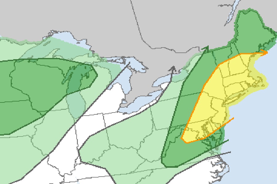
Another rough day of weather is expected in the northeast tomorrow, with an area stretching from New Jersey to Vermont and points east under fire from severe thunderstorm, tornado, and flash flood threats. According to the National Weather Service’s Storm Prediction Center, severe thunderstorms are possible across the northern Mid Atlantic into southern and central New England while their Weather Prediction Center says there’s an elevated threat of flash flooding over Vermont and western Massachussetts.
A shortwave trough currently in the upper Midwest will continue its eastward march into Thursday. This system is forecast to reach New England by early afternoon, setting the stage for wet and wild weather there. A strong mid-level flow will persist across the northern periphery of the upper-level ridge in the northern Plains into the upper Mississippi Valley while a surface low will move through the Northeast along with an associated warm front and a weak front/surface trough trailing into the Blue Ridge/ Piedmont regions. This movement will trigger rounds of severe thunderstorms and heavy rainfall in the northeast.
According to the Storm Prediction Center, atmospheric conditions will be ripe for some storm organization with a mix of discrete cells and multicells while low-level wind fields will be moderately strong and promote a risk for damaging winds with the strongest updrafts. Near the warm front, low-level shear will also favor some potential for low-level rotation and a threat for a couple tornadoes. Should greater surface heating occur, greater risk for damaging winds could be realized.
At this time, the SPC believes there’s an elevated threat of tornadoes from northern New Jersey, eastern New York including all of Long Island and the New York City metro area, all of Connecticut, Rhode Island, much of Vermont and New Hampshire, and southeastern Maine. The SPC believes there’s an even more at-risk zone in the northeast over Massachussetts and southern New Hampshire, including the Boston metro area.
Farther south into the Mid-Atlantic, weaker shear will be present. Stronger surface heating will still promote buoyancy resulting in damaging wind gusts and isolated large hail, especially where severe weather would be moving off of the Blue Ridge in portions of Virginia.
Beyond damaging severe thunderstorms with hail, wind, and tornado threats, there’s also a threat of flooding rains. Atmospheric ingredients will come together to produce convective activity within an anomalously moist airmass where precipitable water values are near 2.0″. Combined with very wet antecedent conditions and still highly elevated stream flows, the National Weather Service and its Weather Prediction Center is concerned about flood threats in the northeast.
“Turn around, don’t drown,” the National Weather Service warns, adding “never drive through flood waters” while discussing the flood threat in the northeast.
