While the weather pattern still doesn’t support all-snow snowstorms for the highly populated I-95 corridor between Washington, DC and New York City, NY, it is supportive of these snow-to-rain scenarios for the northern Mid Atlantic and southern New England areas while far inland/northern areas see more snow. One such new system should impact the region late Sunday night into Monday and Monday night.
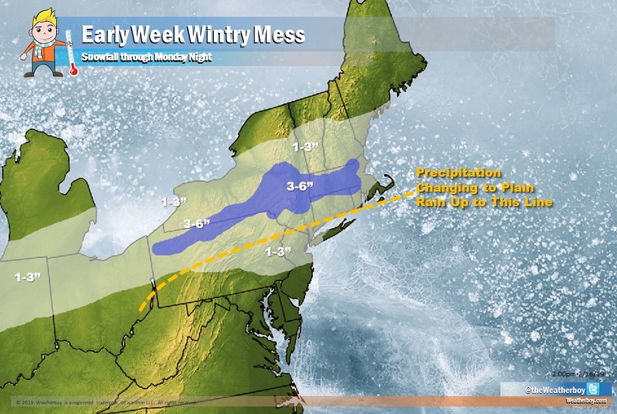
The system responsible for the next sloppy precipitation event makes it move on Sunday. A low pressure system will cross through the Tennessee Valley on Sunday and into the Mid-Atlantic Sunday night. While there are two surface lows present on the models during the this time, the southern low should be the more dominant of the two and the one that looks to be the driver for our weather. The center of the low remains near Virginia. With colder air to the north of the system and limited warm air aloft, mainly snow, especially to the north of west of the I-95 corridor, is expected. This contrasts to last week’s system where cold air allowed for snow to fall in Maryland, Delaware, and southern New Jersey. While cold air will be available at the start, milder air aloft should win, changing light snow to light rain over portions of eastern Pennsylvania, northern/central New Jersey, and the New York City metro area. During the transition, some sleet or freezing rain is expected too which will make conditions slick. North of the rain-changeover area, more sleet and freezing rain are possible, which will put an icy crust on top of the light snowfall accumulation expected there. Where no change-over to rain or sleet/freezing rain is expected, an all-snow scenario will mean a little more in the way of accumulations. There, 3-4″ will be possible, with much of that area over northern Pennsylvania, central upstate New York, and interior Massachusetts.
