After a brief lull in the tropics in a busy season that brought Hurricane Douglas near Hawaii and Hurricane Isaias up the U.S. East Coast, it appears new tropical cyclones are about to form in both basins.
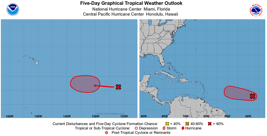
The National Hurricane Center in Miami, Florida believes there is a 90% chance that a tropical cyclone will form in the Atlantic in the next 48 hours. According to their latest Tropical Outlook, first-light visible satellite imagery shows that a better-defined center of circulation is forming in association with a low pressure system located about 900 miles west southwest of the Cabo Verde Islands. In addition, the associated shower and thunderstorm activity has become more organized since yesterday. Because environmental conditions are expected to become more conducive for additional
development, the National Hurricane Center says advisories could be initiated on a tropical depression as early as later today if these development trends continue. If it continues to grow into a named tropical storm, it would be called “Josephine”; the current earliest Atlantic ‘J’ storm on record for now is Jose which formed on August 22, 2005.
While the National Hurricane Center is keeping an eye on the Atlantic disturbance, the Central Pacific Hurricane Center is doing the same with an area of low pressure entering its basin of responsibility. An elongated area of disturbed weather is located around 1,900 miles east-southeast of Hilo on the Big Island of Hawaii. A low pressure system is expected to form within this area in a day or two, and it will likely become a tropical depression late this week. The Central Pacific Hurricane Center reports that the chance of formation is a high 70% over the next five days. This system is expected to move slowly westward toward the central Pacific basin during the next several days.
For now, neither system is an immediate threat to any landmass. But that could change in the upcoming days as both systems head off to the west.
