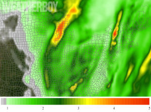
A soaking rainstorm will bring heavy rain to an area that has seen very little the last few weeks in the Eastern US; this October soaker may even create some isolated flooding conditions. A broad swath of moderate to locally heavy rainfall is expected from the Ohio Valley into the Southeast. A deepening low over the Great Lakes will help push a cold front across the area today.

In general, the progressive nature of the system and the expected line of thunderstorms contained within it should cap-off rainfall totals from this storm at about 2″ today. However, some areas will see heavy heavier rains, with some localized 4-6″ amounts possible according to the National Weather Service’s Weather Prediction Center. Because it’s been so dry lately, the overall threat of river flooding is low. However, with some rain showers producing rain fall rates of 1-1.5″/hour, there will be some isolated flash flood risks later today and tomorrow.
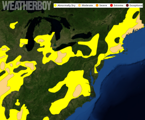
With a lack of rain in the northeastern United States over the last several weeks, drought conditions are resurfacing after soaking rains in the spring washed away drought fears away from earlier in the year. Portions of southeastern New England, the Great Lakes Region, and the Mid Atlantic are considered to be in Moderate Drought Conditions. This soaking rain storm should help alleviate but not eliminate the drought conditions there.