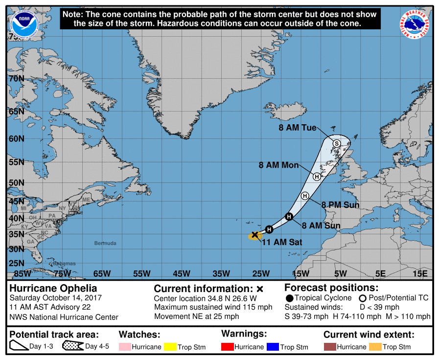
Ophelia is now a Major Category 3 hurricane, the strongest ever recorded for its location, and it’s heading for Ireland and the United Kingdom. Efforts to protect life and property in Ireland should be rushed to completion.
Ophelia is a quite intense and rare hurricane for its location in the northeastern Atlantic. Increasing shear and cold waters will soon begin to impact Ophelia, and the hurricane should begin to acquire extratropical characteristics in about 36 hours or sooner. Although some weakening is anticipated, Ophelia is expected to reach the British Isles as a powerful extratropical cyclone with hurricane force winds. Ophelia could be the strongest storm of its type to impact Ireland.
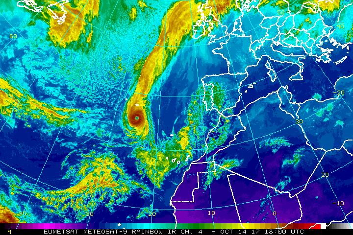
Given that Ophelia is forecast to become extratropical, the wind field should expand, resulting in impacts over portions of the British Isles regardless of its exact location or strength.
Major Hurricane Ophelia is entering the forecast domain of Met Eireann, the official meteorological organization in Ireland. Ophelia will also impact the United Kingdom; there, the Met Office is the official government agency responsible for weather forecasts and advisories.
In Ireland, Met Eireann has issued a STATUS RED alert Wind Warning for Galway, Mayo, Clare, Cork, and Kerry. According to Met Eireann, Ophelia will be “bringing severe winds and stormy conditions . Mean wind speeds in excess of 80 km/h and gusts in excess of 130km/h are expected, potentially causing structural damage and disruption, with dangerous marine conditions due to high seas and potential flooding.” STATUS ORANGE alert is up for the balance of Ireland. “Mean wind speeds between 65 and 80 km/h with gusts between 110 and 130km/h are expected, however some inland areas may not be quite as severe. The winds have potential to cause structural damage and disruption, with dangerous marine conditions due to high seas and potential flooding”, said Met Eireann in their latest update.
In the United Kingdom, the Met Office has issued Yellow Warnings for Central, Tayside, and Fife Grampian Highlands, Eilean Siear, North East England, North West England, Northern Ireland, Southwest Scotland, Lothian Borders, South West England, Strathclyde, Wales, Yorkshire, and Humber. The Met Office warns, “A spell of very windy weather is likely on Tuesday in association with ex-Ophelia. Road, rail, air and ferry services might be affected, with a slight chance of longer journeys times and some roads and bridges could close. There is a slight chance that power cuts may occur, with the potential to affect other services, such as mobile phone coverage.
According to the US National Hurricane Center, dissipation of Ophelia is forecast in about 4 days after the system moved over British Isles. However, windy, rainy conditions will make their way through Northern Europe for many days.
