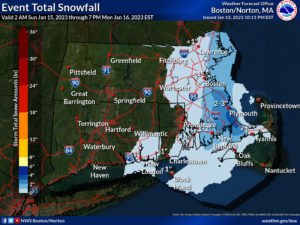
An area of low pressure east of New England is sending snow to portions of extreme southeastern New England; this snow should persist into tomorrow. While this system will simply brush-by the southeast New England coast, there’s no major winter storm threat and no decent chance of any significant snow on the horizon in the east.
Upwards of 4″ of snow is expected, with the greatest amounts north of Cape Cod and south of Boston. A light dusting is possible in Boston and Providence too. Snow showers should wrap up on Monday as the storm pulls away from the coast.

While California continues to be pounded by an onslaught of atmospheric river events, the weather pattern does not favor any typical east coast snow storms this month. And according to long range forecast guidance from both the American GFS and European ECMWF forecast models, the rest of January appears to be as snowless as the first half was.
The GFS and ECMWF are among many computer models meteorologists use to assist in weather forecasting. While meteorologists have many tools at their disposal to create weather forecasts, two primary global forecast models they do use are the ECMWF from Europe and the GFS from the United States. While the models share a lot of the same initial data, they differ with how they digest that data and compute possible outcomes. One is better than the other in some scenarios, while the opposite is true in others. No model is “right” all the time. Beyond the ECMWF and GFS models, there are numerous other models from other countries, other academic institutions, and private industry that are also considered when making a forecast.
For now, both global models suggest more of the same in the northeast: a pattern that just doesn’t support snowstorms one would expect this time of year. While the pattern could evolve and change, especially for the start of February, people along the I-95 corridor from Washington, DC to Boston, MA will unlikely see much in the way of significant snow or even significant snowfall threats anytime soon.
A major snowstorm can happen during any month of the winter season, but in the northeastern United States, they tend to happen most often in February. In fact, February is the snowiest month of the year, on average, for most places across the region, especially along the heavily populated area near I-95 in the northeast. It is too soon to know definitely whether the weather pattern will change to one that favors more snow in the East.