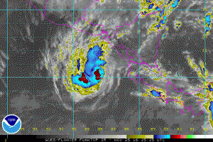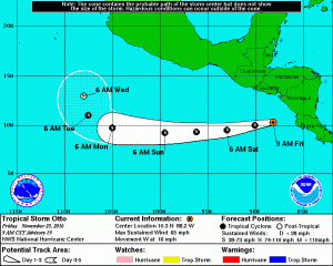
After a devastating impact in Nicaragua and Costa Rica yesterday, Otto has emerged over the Pacific Ocean today. Only 4 storms since 1950 have crossed Central America from the Atlantic to the Pacific:Irene/Olivia (1971), Fifi/Orlene (1974), Joan/Miriam (1988), and Cesar/Douglas (1996). Because of a change in naming convention by the World Meteorological Organization, Otto was not renamed when it entered the Pacific like the storms before it did.
Maximum sustained winds were 110 mph at landfall, making Otto a Category 2 on the Saffir-Simpson Hurricane Wind Scale. Otto was the strongest Atlantic hurricane on record this late in the year, according to Eric Blake, a hurricane specialist with the National Hurricane Center.
At a press conference yesterday, Costa Rican President Luis Guillermo Solis announced, “I regret to inform (you) … that there are people dead and missing.” He said at least 3 people are dead and more than 2,500 people were evacuated for the hurricane.
Soon after the storm made landfall on Thursday, a 7.0 magnitude quake struck 93 miles southwest of Puerto Triunfo, El Salvador, at a depth of 6.4 miles the U.S. Geological Survey said. There were no reports of major damage from the quake, but a Tsunami Warning was issued for the west coast to evacuate coastal areas 1 kilometer (0.6 miles) from shore. A woman died from a heart attach when she heard the Tsunami Warning was issued.
Hurricane Otto dumped about 6-12″ of rain, with isolated amounts of 15-20″ reported.

Today, microwave and conventional satellite imagery shows that Otto’s cloud pattern is a little better organized with a mid-level eye and very deep convection surrounding the center. Estimates from TAFB and SAB are 3.5 on the Dvorak scale, and on this basis, the initial intensity is set at 55 kt by the National Hurricane Center (NHC.) The NHC calls for a weakening trend by the end of the forecast period following the solution of the global models and the previous NHC forecast.
Otto is moving toward the west or 265 degrees at 14 kt within the easterly flow associated with a strong mid-level high over Mexico. This steering pattern is forecast to persist for the next 2 to 3 days, so a general west or even west-southwest track is anticipated. In about five days, Otto should be located on the southwestern edge of the high and should then begin to turn to the northwest and north.
As the storm continues to pull away from Central America, heavy rain will diminish there. Otto is moving toward the west near 16 mph (26 km/h). Maximum sustained winds are near 65 mph with higher gusts. No significant change in strength is anticipated during the ext 48 hours. Maximum sustained winds are near 65 mph with higher gusts. Little change in strength is forecast during the next 48 hours. Tropical-storm-force winds extend outward up to 70 miles from the center. The estimated minimum central pressure is 994 mb (29.36 inches).
Visit our Tropical Weather Page here for further information about this system and a review of all tropical cyclones that were near US waters for the 2016 season: https://weatherboy.com/hurricanes-tropical-weather/