• Skip to primary navigation
  • Skip to main content
  • Skip to primary sidebar

Weatherboy

Weatherboy Weather News, Maps, RADAR, Satellite, and Forecasts.

  • Local
  • Earth Science News
  • RADAR
  • Current Warnings
  • Satellite
  • Current Maps
  • Forecast Maps
  • Video

Pacific Active, but Atlantic Quiets

by Weatherboy Team Meteorologist - July 21, 2017

Latest satellite image of the Atlantic hurricane basin. Image: NOAA


While the eastern Pacific basin remains active, the Atlantic hurricane basin has quieted down after Tropical Storm Don degenerated earlier this week. For the next five days, the National Hurricane Center expects no tropical cyclones to develop anywhere within the Atlantic basin.

While a few tropical waves exist across the basin, none are expected to become a cyclone over the next five days.

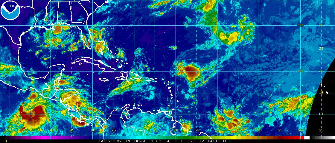
The first tropical wave over the eastern Atlantic extends from 17N 31W to 04N 32W, moving west at 20kt. This wave is along the leading edge of a deep pool of moisture off the coast of Africa. Satellite imagery  shows an extensive area of Saharan dry air and dust northwest of the wave which will inhibit development.


The second wave, a large amplitude one, is  over the central Atlantic with axis from 24N 54W to 08N 55W, moving west at 15 kt.  A portion of this wave is forecast to move across the eastern Caribbean during the upcoming weekend, bringing increasing moisture and probabilities for scattered showers and thunderstorms with gusty winds. Even so, no tropical cyclone development is expected here.

The third wave is over the Eastern  Caribbean with axis from 19N 64W to 08N 65W, moving west at 20 kt. According to the National Hurricane Center, this wave is capable of producing strong gusty winds as it moves west across the eastern Caribbean today, and across the central Caribbean on Saturday and Saturday night. But as with other waves in the basin, no development is expected of this wave in the coming days.

Lastly, the remnants of former Tropical Storm Don is the last wave being tracked in the basin. Located over the Western Caribbean Sea with an axis from 19N 81W through Panama to the East Pacific at 05N 82W, this wave is producing moderate to strong convection along the coast of Nicaragua. This wave is forecast to move to Central America today, with strong gusty winds and shower and thunderstorm activity likely there.


Experts believe this Atlantic Hurricane Season, which runs through to the end of November, will be a busy one.  Dr. Phil Klotzbach and the experts at Colorado State University updated their seasonal outlook again on July 5, showing a much more active than normal season expected. The National Oceanic and Atmospheric Administration  (NOAA) also released their own forecast which shows this hurricane season to be likely more active than others.
Satellite images, forecast models, and the latest advisories for tropical cyclones anywhere near North America can be found on

Primary Sidebar

Sponsored Ad

Search

Latest News

  • Overnight Earthquake Rattles Kentucky Southeast of Cincinnati, Ohio
  • Comet C/2025 K1 (Atlas) Splits Up While Interstellar Object 3I/Atlas Continues to Puzzle Scientists
  • Sun Launches Powerful X Class Solar Flare – Again!
  • After Violent 48 Hours, Earth’s Atmosphere Returns to Normal After Geomagnetic Storm
  • IMPACT! CME Arrives on Earth, Geomagnetic Storm Building; Expected to be SEVERE
  • SEVERE Geomagnetic Storm (G4) Now Expected November 12
  • Earth is Now Picking Up Radio Signals from 3I/Atlas Interstellar Object
  • Shocking New Images of 3I/Atlas Adds to Alien Spaceship Theory by Harvard Scientist
About | Careers | Contact | Contests
Terms | Privacy | Ad Choices
Weatherboy is a (R) Registered Trademark of isarithm LLC, All Rights Reserved.
All content herein is Copyright by Isarithm LLC 1997-2022

Insert/edit link

Enter the destination URL

Or link to existing content

    No search term specified. Showing recent items. Search or use up and down arrow keys to select an item.