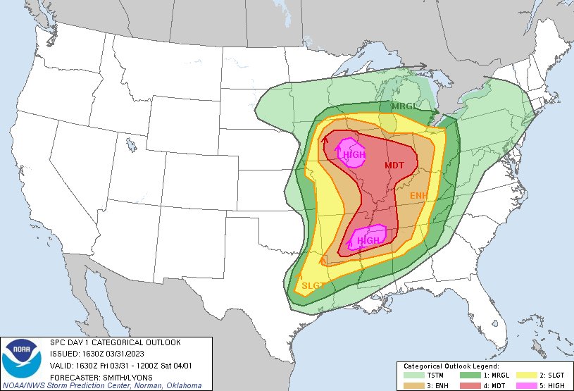
A particularly dangerous situation is unfolding today over portions of Iowa, Illinois, and Missouri, with violent thunderstorms and destructive tornadoes expected over a substantial area. The National Weather Service’s Storm Prediction Center (SPC) says numerous tornadoes are expected with a few intense tornadoes likely; widespread large hail and isolated very large hail events to 3″ in diameter are also likely. Widespread damaging wind gusts to near hurricane-strength are also likely.
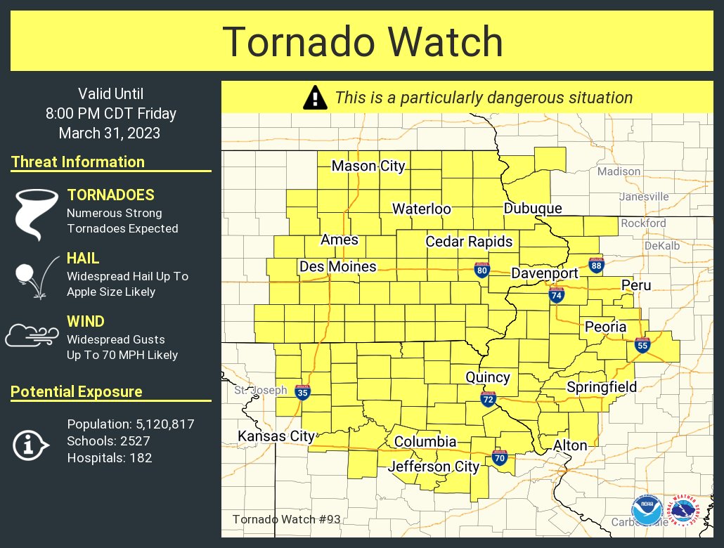
Due to the high threat level, a Tornado Watch has been issued for portions of central and eastern Iowa, western Illinois, northern and central Missouri, and southwest Wisconsin. Additional Tornado Watches and Warnings are likely to be issued later today.
The SPC says intense supercell thunderstorms are expected to develop this afternoon and spread eastward across the current watch area. Tornadoes, large hail, and damaging winds are all possible with this activity; the National Weather Service also warns that atmospheric parameters are ripe for the formation of strong to violent tornadoes and very large hail.
A severe weather outbreak appears increasingly likely, centered on this afternoon and evening, across a large portion of the Mississippi Valley. At least a few long-track, strong to potentially violent tornadoes are probable, particularly over portions of the Mid-Mississippi Valley to the Mid-South. Swaths of intense damaging wind gusts along with very large hail are expected as well.
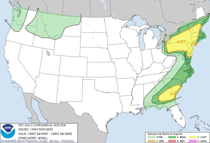
While today’s severe weather outbreak is likely to be more severe than tomorrow’s, strong to severe thunderstorms are expected to push east into the eastern United States tomorrow, with the area around much of Pennsylvania ,upstate New York, and most of New Jersey and Delaware.
For now, a dangerous severe weather outbreak is likely across a large portion of the central states this afternoon into tonight. Long-track, strong to potentially violent tornadoes are forecast across a broad region of the Mississippi Valley. The SPC says, “The propensity of model-supporting evidence and observational trends lends confidence in the upgrade to bimodal High Risks for the mid Mississippi Valley and lower Mississippi Valleys.”
“Upscale growth into a Quasi-Linear-Convective System (QLCS) with embedded supercells appears probable during the late evening and overnight as frontal convergence strengthens,” the SPC warns. ” Tornadoes and significant damaging wind swaths will remain possible well into the night across at least into the Tennessee Valley, until warm-sector low-level flow becomes more veered towards the end of the period.”
While conditions will temporarily stabilize late tonight / early tomorrow, strong thunderstorms may develop and organize east of the lower Great Lakes into the Hudson Valley and northern Mid Atlantic region tomorrow, accompanied by a risk for severe wind gusts.
“While another significant short wave trough begins to dig within the main branch of mid-latitude westerlies, near/offshore of the Pacific
Northwest coast, downstream flow is forecast to become less amplified into and through a confluent regime to the east of the Canadian Prairies and U.S. Great Plains,” the SPC says. “To the south of a lingering vortex of Arctic origins (initially centered over southern Hudson Bay), models suggest that a vigorous short wave perturbation will dig to the southeast of James Bay and come in
phase with an initially more substantive perturbation within this regime,” the SPC adds. By early Sunday, this consolidating mid-level troughing is expected to shift across New England into the Canadian Maritimes .
For Saturday, the strongest mid-level cooling and height falls are forecast to overspread the upper Ohio Valley/lower Great Lakes region through the northern Mid Atlantic and western New England by early Saturday evening. “This may provide the focus for the primary severe weather potential for this period,” the SPC says.
Atmospheric ingredients and expected activity may support severe wind gusts while spreading east-northeastward across southern New York and Pennsylvania through the afternoon, perhaps as far east as the Hudson Valley vicinity by early Saturday evening. Farther east, in areas not impacted by the cool Atlantic marine layer, a gradually waning risk for strong wind gusts may continue into the evening hours.
