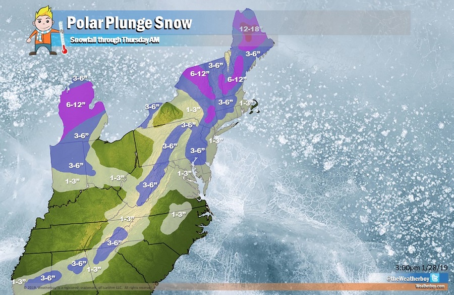
A potent cold front bringing cold Arctic air from the polar regions will bring light snow to a wide area stretching from New England and the Great Lakes south to the deep south. The cold front will provide for a quick but impactful precipitation event during the day Tuesday in the south, Tuesday evening in the Mid Atlantic, and Wednesday morning in New England. By Thursday morning when the storm is finally gone, people will have received generally 1-3″ across a broad area of the eastern US, with some places seeing 3-5″ in places like central Mississippi, northwestern Alabama, northern Georgia including portions of the Atlanta metro area, the higher elevations of West Virginia and central Pennsylvania, the Philadelphia metro area, and the Poconos. In New England, more snow will fall with 6-12″ over northeastern upstate New York, central Vermont and New Hampshire, and portions of Maine. Some places in north-central Maine could even see 12-14″ on the ground by Thursday morning. Overall, this system is a quick mover: precipitation will exit quickly once the cold front moves through for southern New England and all points south.
In portions of the Mid Atlantic and south, the light to moderate snow could start briefly as a period of light rain. As cold air filters into the system, that light rain will change to light snow. With rain falling prior to the snow, road crews won’t be able to pre-treat roads; as such, they could be come especially slick as temperatures dip below freezing as the changeover occurs during the Tuesday PM hours. Rain will keep snow totals low at the coastal plane: places like Delaware Beaches, the Jersey Shore, New York City and Long Island, and southeastern New England will only see an inch or two of snow at most. The Cape Cod and nearby islands will be too mild to support accumulating snow; there, mainly light rain is expected with little/no accumulation forecast.
The much advertised bitter cold will arrive behind this cold front. A secondary cold front attached to an area of low pressure across southeastern Canada will swing through during the afternoon on Wednesday. Gusty winds are expected with and behind the front as the deeper, colder air pours across the northeast. Temperatures will drop some 5 to 10 degrees within a few hours after frontal passage. As this secondary front moves through Wednesday, it could trigger a stray flurry or snow shower; however, no additional accumulation is expected from this south of New England. Again, with a little more moisture and more cold air to work with, additional light accumulation will be possible in New England, especially north central Maine. With winds becoming strong and gusty as the cold air moves in, there could be power issues as branches and wires take a beating on 20-30mph sustained winds with gusts of 30-40mph possible. Winds will lessen by Thursday morning as fair high pressure builds into the northeast.
While the high will provide fair conditions to the eastern U.S. on Thursday, the Polar air will be present. Lows Thursday morning will be well below zero across much of the northeast. Even as far south as Phladelphia and New York City, temperatures will fall into the single digits. Before winds diminish, some early morning wind chill factors will be more than 15 degrees below zero across much of the region.