
A potent nor’easter will impact the northeast on Saturday, bringing coastal flooding, dangerous surf, flooding rains, and damaging winds. While this system is not a tropical cyclone and won’t be anything remotely as bad as recent named storms like Michael or Florence or past storms like Sandy, a variety of damaging and/or severe weather will still threaten lives and properties in the northeast on Saturday. The National Weather Service has started issuing storm-related advisories ahead of the storm’s expected arrival.

Flooding will arrive in two forms: one from heavy rain, the other from coastal inundation from rough and rising seas. While rainfall records won’t be broken by this storm, a moderate amount of rain is expected to fall over a short period of time. Heavy rain over a limited amount of time could create flash flood situations, even well inland. The National Weather Service reminds people to “turn around, don’t drown; never drive through flood waters.” Rainfall on Saturday of 1-2″ will fall over eastern Pennsylvania, southeastern New York, New Jersey, and Connecticut, although most of that will fall within a 3-6 hour period. Beyond flood threats from the rain, the coast will be battered by rough surf and flooding high tides. Rough surf as high as 7-12 feet could break ocean-facing beaches while storm surge flooding of 1-3 feet above high tide could inundate coastal areas.
While precipitation may start out as or mix with snow at the beginning in higher elevations of the northeast, this will be primarily a rain event. No significant snowfall accumulation is expected from this system.
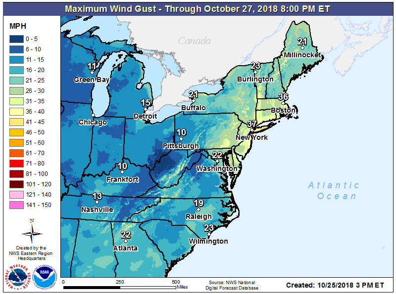
Beyond the floods, the winds will be another problem. Wind gusts of 40-60mph are possible at the immediate coast on Long Island, the Jersey Shore, and Delaware Beaches. But even further inland, wind gusts over 30mph are possible over eastern Pennsylvania, central and eastern Maryland, all of New Jersey, southeastern New York, southern Vermont, and all of Massachusetts, Rhode Island, and Connecticut. Combined with soaked soils, trees could shift and fall in wind gusts. Because not all trees have dropped their leaves yet, some trees, especially in portions of Maryland, Pennsylvania, and New Jersey may be more susceptible to failure from lighter winds than stronger winds to leave-less trees to the north. With Halloween and November elections around the corner, residents are encouraged to secure anything they may have brought outside recently ranging from holiday decorations to campaign signs. With strong wind gusts, with the strongest at the coast, power outages are possible. Plans should be made before the storm arrives to deal with the possibility power may be out after the storm departs.
For the heavily populated area around the I-95 corridor, the storm will come in parts: potent storm, dry slot, wrap-around light shower activity, and a weak secondary system 24-30 hours later. The potent storm will strike early Saturday. In Washington, DC, the worst will be 6pm Friday to 6am Saturday. In Philadelphia, PA, and New York, NY, the worst will be midnight Saturday morning to 2pm Saturday afternoon. In Boston, the worst will be from noon Saturday to midnight Saturday night/Sunday morning. The dry slot, an area of the storm featuring plenty of clouds but only light drizzle and shower activity, will enter Washington, DC around 6am Saturday, at around noon in Philadelphia,around 8pm Saturday in New York, and around 6am Sunday in Boston. While some lingering light shower activity will persist beyond this time, the next round of appreciable precipitation will hold off until around midnight Sunday night / Monday morning for Washington, DC, lunchtime on Monday for Philadelphia and New York, and dinnertime Monday for Boston.
