A potent storm will continue to move up the east coast today, bringing heavy rain and damaging winds to locations closer to the coast and heavy snow far inland. A strong surface low over the southeastern US responsible for last night’s tornado outbreak in Georgia and Florida will progress northeastward to off-shore the Mid Atlantic coast by dinner time today. Meanwhile, a surface high pressure system will drift southward across eastern Canada today. In between this area of high and low pressure, the pressure gradient will continue to increase, leading to strong east to northeast winds throughout the day.
Wind will be a major threat today with increasing speeds throughout the day. This morning, several sites in/around New Jersey are already reporting 35-45mph winds and they will continue to increase throughout the day.
Computer forecast models that meteorologists use to aid their forecasting ability suggest a south to north push of the strongest winds this morning from south of the Mason-Dixon Line to northern/central New Jersey and the New York City metro area by this evening as the surface low moves northeastward off the coast of the DelMarVa Peninsula.
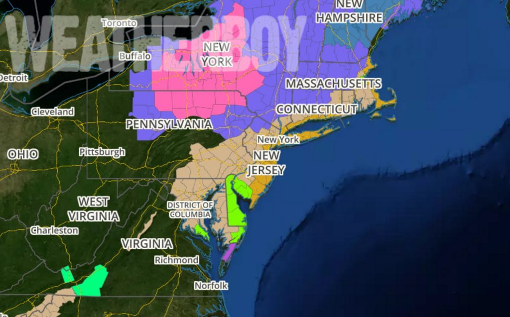
Because of these winds, the National Weather Service has issued High Wind Warnings and Wind Advisories for many counties today.
In New Jersey, Atlantic, Cape May, Burlington, Middlesex, Monmouth, and Ocean Counties are under a High Wind Warning ’till 4pm for southern NJ counties and ’till 9pm for central NJ counties. In northern New Jersey, High Wind Warnings are up through 1am for Hudson, Essex, and Union counties. High Wind Warnings are up ’till 1am tonight for Fairfield, New Haven, Middlesex, New London counties of Connecticut; they’re also up for Manhattan, the Bronx, Staten Island, Brooklyn, Suffolk, Queens, and Nassau counties in New York until 1am tonight. A High Wind Warning goes in effect at 1pm today and runs through to 7am tomorrow for Essex, Plymouth, Barnstable, Dukes, and Nantucket in Massachusetts and Block Island, Rhode Island. In these High Wind Warning areas, sustained winds of 40mph are expected for at least 1 hour with gusts of 58mph or greater possible at anytime; some gusts may reach 60-70mph at times, especially along the immediate coastline. Damage to trees, power lines, and property are possible with winds of this magnitude; power outages are likely. If you haven’t done so already, loose outdoor objects should be secured.
Further inland, Wind Advisories are up. Wind Advisories are issued when very windy conditions are expected. Winds this strong can make driving difficult, especially for high profile vehicles. Light-weight outdoor objects such as patio furniture and garbage cans should also be secured. Some power outages are possible in Wind Advisory areas due to falling tree branches and electrical wires. The Wind Advisories are up for the balance of New Jersey not under the more severe High Wind Warning, all of Delaware, eastern Maryland and Pennsylvania, the rest of southern Connecticut, all of Rhode Island, and much of eastern Massachusetts not already covered by High Wind Warnings.
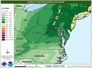
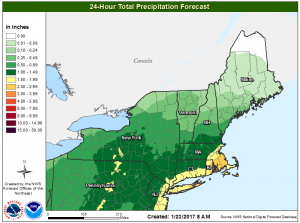
Heavy rain will also makes its way north up the coast. Right now, the heaviest rain, roughly 2-3″, will fall across portions of Rhode Island and Massachussetts. 1.5-2.5″ will fall across southern Connecticut, Long Island, the entire New York City metro area, and the eastern half of New Jersey. While beneficial to the drought in the region, too much rain falling too quickly may lead to some flooding issues.
Beyond rain water flooding, there’s also the threat of coastal flooding at times of high tides, especially over Delaware and New Jersey. In addition to coastal flood threats, there will be significant beach erosion from those stiff east winds, especially at the Jersey Shore.
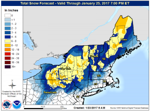
Precipitation more typical of winter will also impact the northeast, although the most frozen precipitation will be far north and west away from the major I-95 cities. A Winter Weather Advisory Advisory was issued for Carbon and Monroe Counties in Pennsylvania and Sussex County, New Jersey for this morning through Tuesday morning. First, temperatures will continue to fall, most precipitously, across northeastern Pennsyvlania and northwestern New Jersey this morning as cold air from high pressure over eastern Canada drains southward. For the highest elevations in Monroe County (above 1500 ft), freezing rain and freezing drizzle is expected once temperatures drop below freezing this morning. The freezing level will lower to about 1000 ft in elevation by late this morning and afternoon, resulting in pockets of icing along the ridges in Carbon and Sussex Counties. Looking at forecast thermal profiles aloft indicates sleet mixing in at times in the advisory area this afternoon as the pocket of low-level cold air deepens and steadier precipitation moves in. A change over to wet snow is possible at the higher elevations if there is enough dynamical cooling present to erode the warm layer aloft; this will likely happen at or after sunset. Snow and snow/sleet mix looks to become heavy for a period tonight. Further north and west over central Pennsylvania, upstate New York, and interior New England, there will be more cold air to work with, allowing for more snow than other precipitation types. as a result, heavier snowfall amounts greater than 6″ is expected there. Some higher elevations may see amounts top out in the 8-12″ range.
As this storm exits, we’ll be monitoring a pattern change we’ve been forecasting for quite some time. Temperatures will plunge across the eastern United States and new threats for snow will arrive as we move into February. More on that pattern change can be read here: https://weatherboy.com/significant-pattern-change-arriving-soon/
