If you’re a snow lover in the Eastern United States, after weeks of disappointment, a significant pattern change arriving soon may provide you with what you seek: plenty of cold and the potential for snowy winter storms.
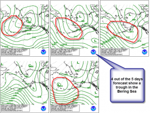
After the major ice storm across the Plains late last week and weekend and a winter storm for interior New England Tuesday night, the weather pattern will warm up and snow or ice events will become rare over the next 2 weeks or so. Temperatures will be 5-10+ degrees above normal for several days at a time across a large area of the country. The Bering Sea Rule (BSR) advertised this change to a mild weather dominated by Pacific air masses over the lower 48 several weeks ago.
Now, the BSR shows a major pattern change to much colder weather towards the end of January lasting into February. And this isn’t the only long-range forecasting tool that shows this potential for arctic invasions. The higher atmosphere (stratosphere) near the North Pole shows the signs of a sudden stratospheric warming event (SSW) that could combine with the troughiness shown by the BSR to give the East and Central part of the United States their coldest weather of the year.
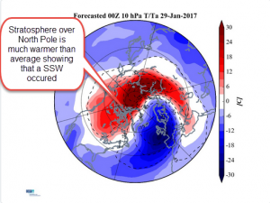
According to Dr. Judah Cohen, who is the Director of Seasonal Forecasting at Atmospheric and Environmental Research which is a division of Verisk Analytics, “It has been shown that following a sudden stratospheric warming the weather turns colder in the Eastern US and Northern Eurasia. The models are all now converging on a sudden stratospheric warming by the end of the month. This should set up cold February and possible March in the Eastern US.”
This SSW setting up is a major one with its effects likely lasting longer than just one brutal cold snap; this is why Dr. Cohen suggests the cold spell could spill into March. Major SSW events can take a week or two for changes to become noticeable in your backyard but their pattern-changing power can last for several weeks and sometimes much longer; for as long as 60-90 days. An event like this one has the potential to completely reverse a winter that is running slightly above normal temperature-wise to one running several degrees below normal. And this major SSW event also has the potential to bring a chilly early part of the spring as well.
However, Dr. Cohen does caution, “The timing (of the SSW) is very important and I still consider that there is much uncertainty as to when the stratospheric warming will peak and that could have important implications for when the cold becomes persistent.” A delicate balancing act may be in the cards, with a major question remaining: “Will the trough across the East coincide with the delivery of the coldest air of the season?” If these two do not sync up and occur at different times, a trough will exist in the East without true Arctic air. The Arctic blast of the SSW could then be ushered into a different part of the world late in the month. The Arctic air could also slowly build up, take hold of the North American continent and dominate much of February and potentially parts of March.
As always, a long-range forecast is a fluid beast. Small, seemingly almost insignificant changes can affect the setup of the weather pattern in huge ways. Thus, winter weather fans will be watching over the next few weeks about how the weather pattern evolves.
