A potent storm system will impact the eastern half of the U.S. late tomorrow into Monday bringing a round of accumulating snow and heavy rain to a large area on the last day of November. The storm system will help usher in colder air across the eastern U.S. setting the stage for a cold start to December for many.
High pressure in place today over the eastern U.S. will give way to a developing area of low pressure tomorrow. A southern stream low currently located in desert southwest will phase with a northern shortwave in the vicinity of the Ohio Valley and Great Lakes region Sunday night into Monday. Eventually becoming a closed low over southern New England on Tuesday, the storm will move north into Canada with high pressure returning by the middle of the week.
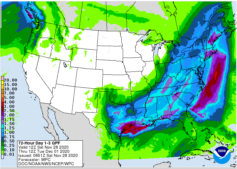
Before the storm exits the U.S., moderate to heavy precipitation is expected. 3-5″ of heavy rain is expected along the Gulf coast of Texas and Louisiana. New England could also see 2-3″ of heavy rain. Widespread 1-2″ amounts of rain are expected through much of the eastern U.S. Cold air arriving on northwest winds will help turn precipitation over Indiana, Ohio, West Virginia, and the higher hills of the Appalachians to snow. Several inches of snow are likely to accumulate in this region, producing the first widespread snowfall in the area for the season.
This time of weather set-up could also produce some severe weather. The greatest risk of severe weather will exist from New Jersey south to Florida along the East Coast. Damaging wind gusts are the greatest threat within the severe weather event.
