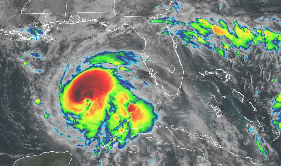
A potentially catastrophic major hurricane continues to gain strength in the Gulf of Mexico: Hurricane Michael is forecast to strike the Florida Panhandle tomorrow, sending an incredible storm surge inland as destructive winds, waves, and flash-flooding rains blow through the region. It appears Major Hurricane Michael will make landfall somewhere between Destin and Apalachicola, Florida late tomorrow afternoon.

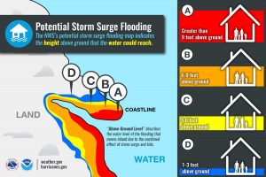
It’s simplistic in that the water levels depicted describe the height above ground that water could reach at a given location. Image: NHC
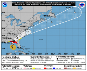
With numerous life-threatening conditions arriving on the Gulf Coast tomorrow, a variety of advisories have been issued by the National Hurricane Center. A Storm Surge Warning is in effect for an area between the Okaloosa/Walton County Line in Florida to the Anclote River in Florida. A Storm Storm Surge Watch is in effect for two areas: from the Anclote River to Anna Maria Island, Florida, including Tampa Bay; the second extends from the Alabama/Florida state border to the Okaloosa/Walton County Line in Florida. A Storm Surge Warning means there is a danger of life-threatening inundation, from rising water moving inland from the coastline, during the next 36 hours in the indicated locations. A Storm Surge Watch means there is a possibility of life-threatening inundation, from rising water moving inland from the coastline, in the indicated locations during the next 48 hours. A Hurricane Warning is in effect for the area between the Alabama/Florida state border to the Suwannee River in Florida. A Hurricane Warning means that hurricane conditions are expected somewhere within the warning area. A warning is typically issued 36 hours before the anticipated first occurrence of tropical-storm-force winds, conditions that make outside preparations difficult or dangerous. Preparations to protect life and property should be rushed to completion before dinnertime today. A Tropical Storm Warning is in effect for an area that includes the Alabama/Florida state border to the Mississippi/Alabama state border and from the Suwanee River in Florida to Chassahowitzka, Florida. A Tropical Storm Watch is in effect for the area between Chassahowitzka to Anna Maria Island, Florida, including Tampa Bay. A Tropical Storm Watch is also in effect from the Mississippi/Alabama state border to the Mouth of the Pearl River. On the Florida Atlantic coast, a Tropical Storm Watch is also in effect from Fernandina Beach, Florida to the South Santee River in South Carolina. A Tropical Storm Warning means that tropical storm conditions are expected somewhere within the warning area within 36 hours. A Tropical Storm Watch means that tropical storm conditions are possible within the watch area, generally within 48 hours.
A potentially lethal storm surge, destructive winds, and flooding rains are the primary hazard threats from Hurricane Michael. People in the warning area should take all appropriate action to protect life and property immediately.

As of the 2pm ET advisory from the National Hurricane Center (NHC), Michael was still gaining strength. The eye of Hurricane Michael was located near latitude 25.4 North, longitude 86.4 West. Michael is moving toward the north near 12 mph . A northward motion is expected through tonight, followed by a northeastward motion on Wednesday and Thursday. On the forecast track, the center of Michael will move across the eastern Gulf of Mexico through tonight. The center of Michael is then expected to move inland over the Florida Panhandle or Florida Big Bend area on Wednesday, and then move northeastward across the southeastern United States Wednesday night and Thursday, and move off the Mid Atlantic coast away from the United States by Friday.
Data from an Air Force Reserve Hurricane Hunter aircraft inside the storm indicate a powerful storm. Maximum sustained winds measured by the aircraft are near 110 mph with higher gusts. The National Hurricane Center says additional strengthening is expected, and Michael is forecast to be a major hurricane at landfall in Florida. Hurricane Michael is currently forecast by NHC to have max sustained winds of 125 mph near its time of landfall. If that were to verify as its landfall intensity, Michael would tie with Eloise (1975) & the Pensacola Hurricane (1882) for strongest winds for a Florida Panhandle landfall on record. After landfall, weakening is expected as Michael moves through the southeastern United States.
Right now, Hurricane Michael is a relatively compact storm. Hurricane-force winds extend outward up to 35 miles from the center while tropical-storm-force winds extend outward up to 185 miles. A NOAA buoy near the storm, 42003, recently reported 1-minute mean winds of 54 mph and a wind gust of 59 mph . The latest minimum central pressure based on data from the aircraft is 965 mb or 28.50 inches.
Of the likely hazards at landfall, storm surge could be the worst. The combination of a dangerous storm surge and the tide will cause normally dry areas near the coast to be flooded by rising waters moving inland from the Gulf of Mexico shoreline. The water has the potential to reach the following heights above ground if peak surge occurs at the time of high tide:
- Indian Pass, Florida to Cedar Key, Florida: 8-12 feet
- Cedar Key, Florida to Crystal River, Florida: 6-8 feet
- Okaloosa/Walton County Line in Florida to to Indian Pass, Florida: 6-9 feet
- Crystal River, Florida to Aripeka, Florida : 4-6 feet
- Aripeka, Florida to Anna Maria Island, Florida including Tampa Bay: 2-4 feet
- Alabama/Florida state border to Okaloosa/Walton County Line in Florida: 2-4 feet
Destructive winds are expected to impact the area closest to the eye of the hurricane at landfall. Hurricane conditions are expected within the hurricane warning area along the U.S. Gulf Coast by Wednesday, with tropical storm conditions expected by tonight or early Wednesday. Hurricane conditions will also spread well inland across portions of the Florida Panhandle, southeastern Alabama and southwestern Georgia. Tropical storm conditions are expected in the tropical storm warning area by tonight or early Wednesday, and are possible within the tropical storm watch area by that time. Hurricane conditions are possible within the hurricane watch area by Wednesday. Tropical storm conditions are possible in the watch area along the
southeast U.S. coast Wednesday night and Thursday.
Beyond storm surge flooding from the Gulf of Mexico, fresh water flooding from very heavy rains could create a variety of life threatening conditions even far from where Hurricane Michael strikes land. In Cuba today, Michael is responsible for an additional 4-8″ of rain, with isolated amounts of 12″. Rain in Cuba will lead to life-threatening flash floods and mudslides. Along the Florida Panhandle and the Big Bend, southeast Alabama, and southern Georgia, 4-8 ” with isolated maximum amounts of around a foot are expected. Such heavy amounts here will lead to life threatening flash floods. In eastern Georgia, the Carolinas, and southern Virginia, 3-6″ of rain is expected; here, such amounts could also create flash flood problems. Across the Florida Peninsula, the eastern Mid Atlantic, and southern New England coast, 1-3″ of rain can be expected.
Powerful winds from Hurricane Michael are kicking up the surf below it. Swells generated by Michael are affecting the coasts of the eastern and northern Gulf of Mexico and will spread to portions of the northwestern and western Gulf of Mexico coast during the next day or so. These swells are likely to cause life-threatening surf and rip current conditions. Even experienced swimmers and surfers should avoid the water until well after Hurricane Michael passes.
Lastly, there is also a hazard of tornadoes that will increase with Hurricane Michael’s arrival. The threat for tornadoes will increase late tonight into Wednesday over parts of the Florida Panhandle, the northern Florida Peninsula, and southern Georgia. Rain and wind may obscure some tornadoes from view.