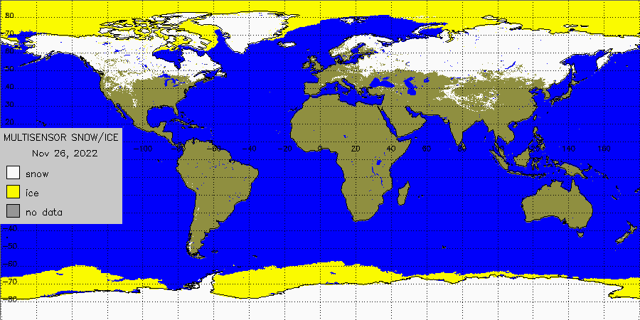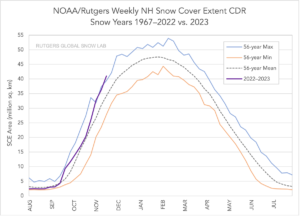
There is a record amount of snow and ice in the Northern Hemisphere today, with more snow and ice covering portions of the hemisphere than at any other time at this time since records were kept over the last 56 years. The expanse of snow and ice could set the stage for a cold, snowy winter in parts of the world with such ground cover helping to reflect sunlight and keep temperatures lower than usual.

According to the United Nation’s World Meteorological Agency and their Global Cryosphere Watch, based on data tracked and analyzed by NOAA in the U.S., snow and ice cover has been tracking at an above normal pace for more than a month, setting the stage for a potential overall winter record. According to NOAA, global snow and ice cover was tracking to the 56-year mean for August and September. But in late October and November, not only did snow and ice cover expand beyond the 56 year mean, it also exceeded the 56 year maximum value. The peak of snow and ice extent usually occurs in February/March; it is too soon to tell whether the winter of 2022-2023 will continue to break records.
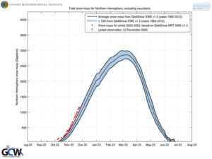
Analysis by European experts shows the same. The Finnish Meteorological Institute has been tracking snow and ice extent since 1982; their analysis shows that the 2022-2023 winter season is running above the previous maximum totals for the 1982-2012 period. As with the NOAA analysis, it is too soon to tell whether or not the record amount of snow and ice cover across the Northern Hemisphere will persist in the weeks and months ahead. It is important to point out that the Finnish analysis ignores snow and ice cover on top of high mountains where snow and ice usually is present.

According to NOAA’s Winter Outlook, this year La Niña is forecast to return for the third consecutive winter, driving warmer-than-average temperatures for the Southwest and along the Gulf Coast and eastern seaboard. While NOAA’s U.S. Winter Outlook released by the Climate Prediction Center suggests milder temperatures over a large part of the U.S., that doesn’t necessarily translate to less snow and ice. Starting in December 2022 through February 2023, NOAA predicts drier-than-average conditions across the South with wetter-than-average conditions for areas of the Ohio Valley, Great Lakes, northern Rockies and Pacific Northwest.