• Skip to primary navigation
  • Skip to main content
  • Skip to primary sidebar

Weatherboy

Weatherboy Weather News, Maps, RADAR, Satellite, and Forecasts.

  • Local
  • Earth Science News
  • RADAR
  • Current Warnings
  • Satellite
  • Current Maps
  • Forecast Maps
  • Video

Severe Weather Event Unfolding in Mid Atlantic Today

by Weatherboy Team Meteorologist - August 25, 2020

While thundershowers are possible in the light green area, strong to severe thunderstorms are possible in the dark green area. The yellow area has an even higher chance of severe thunderstorms, with the orange area showing the greatest threat of severe weather today. Image: NWS


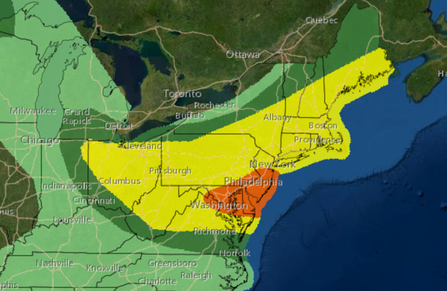
A severe weather event is unfolding in portions of the Northeast and Mid Atlantic today, prompting the National Weather Service to issue Severe Thunderstorm Watches.

SevereWx0825a
A Severe Thunderstorm Watch has already been issued for portions of Ohio, Pennsylvania, and New York. Additional watches and warnings are likely south and east of this area later today. Image: NWS

While thunderstorms can produce isolated tornadoes and large, damaging hail, the greatest threat from today’s storms will be in the form of strong, straight-line winds which could gust 50-65+ mph this afternoon and evening.  According to the National Weather Service, the greatest severe-thunderstorm threat today appears to be for damaging thunderstorm winds over portions of the Mid-Atlantic.

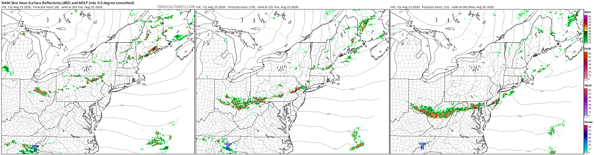
Atmospheric ingredients are coming together to “bake” an environment ideal for severe thunderstorm formation this afternoon.  Strengthening low and mid-level wind fields will develop as an upper-level trough amplifies slightly while moving east, and an increase in large-scale ascent associated with the upper trough should aid in thunderstorm development or re-intensification  this afternoon.  Clusters or line segments capable of damaging winds will be the primary risk as storms move southeast through this evening.


A high resolution, short-duration computer forecast model RADAR simulation shows the area of thunderstorms blossoming and moving south with time this afternoon and evening. Image: tropicaltidbits.com


While not everyone in featured in today’s Convective Outlook yellow and orange areas will see a thunderstorm, those that do could experience severe wind gusts which could cause damage, such as blow-out windows, knock-down trees and tree limbs, and snap electrical wires or poles. Before the storms arrive, people should take care to secure and/or bring in any items that may blow about as the gusty storms approach.

While the risk of isolated tornadoes is very low in this type of atmospheric set-up, there is a slight chance that some of these storms will have large hail. However, the primary threat will remain the strong, damaging wind gusts that’ll be possible as these storms move through.


Primary Sidebar

Sponsored Ad

Search

Latest News

  • Weak Morning Earthquake Rattles Maine
  • Nor’Easter Keeping Weather Cool and Damp in Northeast This Week
  • Miami’s National Hurricane Center Monitors Area for Cyclone Development
  • Scientists Unlock Climate Change Secrets: Say Ice Age Is Coming
  • Tornado Confirmed in New Jersey
  • National Hurricane Center Initiates Daily Reports Today
  • Severe Weather Likely Across Broad Area on Friday
  • Heat Blast Expected from Texas to Florida and from Minnesota to Arkansas
About | Careers | Contact | Contests
Terms | Privacy | Ad Choices
Weatherboy is a (R) Registered Trademark of isarithm LLC, All Rights Reserved.
All content herein is Copyright by Isarithm LLC 1997-2022