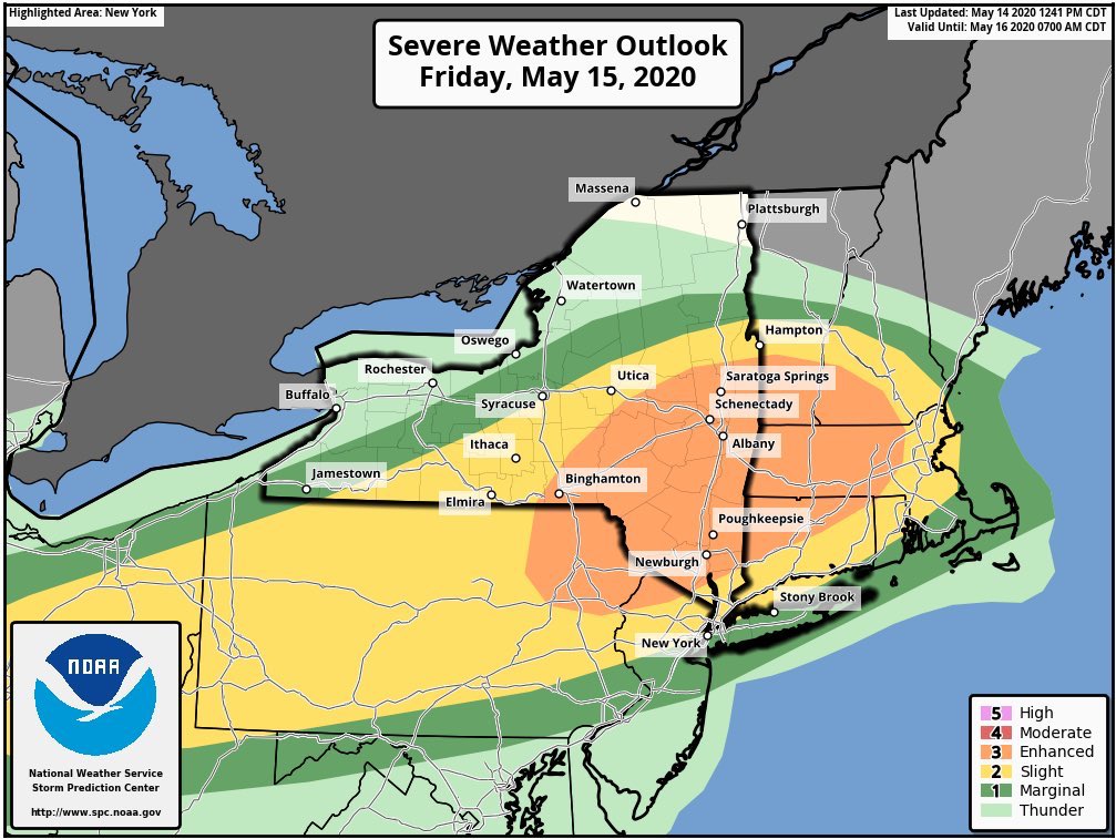
While the East Coast is keeping an eye on a developing tropical or subtropical system, it also needs to focus on a more immediate weather threat: a severe weather outbreak is expected in the northeast on Friday. There is an elevated threat of tornadoes, damaging winds, and large hail over portions of Pennsylvania, New Jersey, New York, Vermont, New Hampshire, Massachusetts, Rhode Island, and Connecticut. The greatest threat of violent weather is over southeastern Upstate New York, southern Vermont, southwestern New Hampshire, central and western Massachusetts, and northwestern Connecticut.
Today, isolated to scattered severe thunderstorms are possible later this afternoon into tonight from eastern Kansas into the Ohio Valley, and in the vicinity of northwest Oklahoma. The disturbance responsible for this rough weather is forecast to march north and east, bringing severe thunderstorms to portions of the northeast by Friday afternoon. A shortwave trough now located over North Dakota near the international border with Canada will continue to push into the Great Lakes tomorrow, reaching the northeast states later Friday afternoon and evening. According to the National Weather Service’s Storm Prediction Center, by late afternoon on Friday, the accompanying cold front should extend from a surface low in upstate New York southwest into the lower Great Lakes and Ohio Valley. A warm front will extend from the surface low through southern New England, with mild, moist air surging north with it.
Thunderstorms are expected to redevelop along and ahead of the front by the early to mid afternoon hours as the warm air becomes unstable. Upper level atmospheric ingredients will support organized storms including a few supercells and bowing segments with damaging wind the main threat. The low-level jet stream is forecast to strengthen by late afternoon into early evening across the northeast, signaling the possibility that tornadoes can form too. While the tornadoes will be a threat, straight-line winds will be a bigger threat across a broader area of the northeast. Gusty thunderstorms may down trees and powerlines, resulting in power outages. Due to the ongoing COVID-19 pandemic, it may take crews longer than usual to restore any service outages. In addition to wind and tornado threats, there’s also a threat of large hail.
There’s also a threat severe storms could roll through during the overnight hours in the northeast tomorrow night / early Saturday morning. Before going to bed, residents should make sure they can hear and take action around any tornado or severe thunderstorm warning that could be issued.