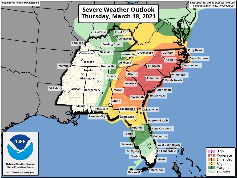
After a day of numerous destructive tornadoes in the south, it appears likely that another severe weather outbreak will occur in the southeast on Thursday. According to the National Weather Service’s Storm Prediction Center, a regional outbreak of severe storms and tornadoes is possible on Thursday from parts of east-central Georgia northeastward across South Carolina and North Carolina. Significant tornadoes, wind damage and large hail will be possible from morning into afternoon. Severe thunderstorms will also be possible from parts of the eastern Gulf Coast into the southern and central Appalachians.
A positively-tilted upper-level low will move into the Tennessee Valley on Thursday as a potent mid-level jet moves across the Southeast and Carolinas. At the surface, a low will move eastward into the central Appalachians. During the morning, a warm front located in northern Georgia east across northern South Carolina will move northward across central and eastern North Carolina by lunchtime. To the south of this front, surface dewpoints across the warm sector will be in the mid to upper 60s. As surface temperatures warm, a pocket of moderate instability is expected to develop to the south of the warm front across eastern North Carolina by late morning. Convective development will be aided by the low-level jet and could lead to tornado formation. Severe thunderstorms associated with large hail, wind damage and a tornado threat, is expected during the mid morning hours.
Further to the west, a band of large-scale ascent associated with the approaching upper-level system will overspread the central Appalachians around midday. Thunderstorms are expected to initiate just ahead of this band around lunchtime and move east into the Appalachian foothills during the early afternoon. Ahead of these storms, the environment will support intense supercell development. Tornadoes, wind damage and large hail will be likely with the stronger storms. A long-track tornado will be possible along or in the vicinity of the warm front too. The greatest threat will occur between noon and 4pm.
The National Weather Service’s Storm Prediction Center warns that a regional outbreak of severe storms, along with several significant tornadoes, are expected from discrete cells that develop across the warm sector from central North Carolina southward across much of South Carolina.
Further to the southwest into Georgia, a line of strong to severe thunderstorms is expected to move into the area form the west during the morning. A corridor of moderate instability is forecast to develop just ahead of this line by late morning with instability continuing to increase through the afternoon. Here, conditions will be ripe for supercell and severe bowing line segments. Supercells that form in the line may produce tornadoes, wind damage and large hail. A potential for significant tornadoes will exist with cells that form at the north end of gaps in the line. This band of storms is expected to be accompanied by widespread wind damage, moving across eastern Georgia and South Carolina during the mid to late afternoon hours. Wind gusts of greater than 70 mph will be possible with the more intense bowing line segments. The southern part of the band may extend as far south as the Florida Panhandle, where a severe threat will exist in the morning and early afternoon.
Large hail, wind damage and a tornado or two will also be possible across the upper Ohio Valley during the
afternoon.
To the north and east, across much of Maryland, Delaware, southern Pennsylvania, and New Jersey could see some thunderstorms. However, they are not expected to reach severe limits at this time. Nevertheless, lightning could still be deadly. The National Weather Service cautions that if thunder is close enough to be heard, lightning is close enough to kill; if thunder is heard, people should head indoors.
