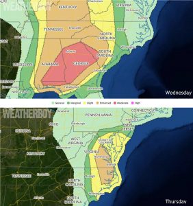
A severe weather outbreak is likely as a potent storm system travels through the southeastern United States and into the Mid Atlantic this week. An outbreak of severe thunderstorms is possible across much of the Southeast, northward along and west of the Appalachians into the
Ohio Valley, Wednesday through Wednesday night. This is expected to include supercell development with a risk for tornadoes, some of which could become strong and long-lived, particularly across parts of the Southeast.

As large-scale ridging builds across the U.S. Rockies and Canadian Prairies, large-scale downstream troughing is forecast to continue to evolve east of the high Plains through the Appalachians by Thursday morning. Computer forecast models that meteorologists use to aid their forecasting show a significant surface cyclogenesis should be underway by Wednesday morning across southern Missouri, associated with a vigorous short wave impulse within the southern stream of split westerlies. This short wave is forecast to turn northeast of the southern Rockies today. Guidance indicates at least some interaction or phasing of the two streams is possible Wednesday into Wednesday night, with at least one northern stream impulse digging across the northern Plains/mid Missouri Valley into the evolving larger scale upper troughing by the Thursday.
This interaction remains a point of model uncertainty, and will have an impact on the track and rate of deepening of the surface cyclone. Nevertheless, the models generally indicate at least slow further deepening, as the low migrates through the lower Ohio Valley into the upper Ohio Valley/lower Great Lakes region by Thursday morning.
South of this area of low pressure, an associated cold front is expected to eventually surge east of the Mississippi Valley through the Appalachians. Low-level moisture will still be in the process of returning ahead of the front, in the wake of a prior system. This remains the primary uncertainty which could temper the overall severe weather potential somewhat, as the environmental conditions associated with evolving synoptic system appear otherwise favorable for an outbreak of severe storms over a broad area east of the Mississippi Valley into the vicinity of the Appalachians. Confidence in sufficient moistening and destabilization are increasing.
For the Southeast tomorrow, in the presence of at least modestly steep mid-level lapse rates and wind profiles becoming characterized by strong deep layer shear and sizable low-level hodographs, considerable organized severe weather potential appears to exist. This is expected to include discrete supercells accompanied by the risk for large hail and tornadoes. In the wake of initial convective development expected to spread northward across and to the lee of the southern Appalachians during the day, guidance suggests new discrete storm development is possible within a low-level confluence zone across southern/eastern Alabama into western Georgia, with the environment ahead of this activity possibly becoming conducive to long-lived supercells with potential for strong tornadoes.
Organized severe storm development is possible across parts of the Mid Atlantic Coast region Thursday, mainly prior to the 2-4 pm ET time frame. This includes a risk for supercells with potential for tornadoes, and perhaps a narrow evolving squall line accompanied by potential for damaging surface gusts.
An amplification within the westerlies appears likely to continue translating across the central into eastern U.S. during this forecast period, with large-scale ridging shifting east of the U.S. Rockies and Canadian prairies, and downstream troughing progressing across the Appalachians into the Atlantic Seaboard. A deep lower/mid tropospheric cyclone embedded within this latter feature is forecast to migrate northeastward near or just east of the lower
Great Lakes region, with a trailing cold front surging southeastward off the Atlantic Coast and through much of the Gulf of Mexico.
Stable conditions associated with cooling and/or drying in the wake of the front will result in low to negligible convective potential across much of the nation. However, prior to the frontal passage, models continue to indicate a window of opportunity for organized
severe storm development across the Mid Atlantic Coast region.
As the exit region of a cyclonic jet streak noses across the region early Thursday, models indicate renewed surface cyclogenesis will take place to the east of the central Appalachians, with rapid deepening and occlusion probable as the low center tracks north northeastward out of northern Virginia. Prior to the frontal passage, coinciding strengthening of southerly 850 mb flow in excess of 50 kt is forecast within the warm sector, along with at least a narrow corridor of substantive boundary layer moistening (mainly near/east of the Interstate 95 corridor of eastern Virginia into northeastern North Carolina. In the presence of strong forcing for ascent this is expected to contribute to sufficient destabilization to support vigorous thunderstorm development. This may include discrete supercells capable of producing tornadoes, given the strength of the wind fields and shear. Considerable wind damage potential may evolve with any upscale growing convection, however the impact of the cooler more stable marine layer near/across the Chesapeake remains unclear as activity attempts to spread northward into/through the DelMarVa
Peninsula.
In addition to creating tornadoes and large, damaging hail, these potent thunderstorms in the southeast and Mid Atlantic may also be accompanied by heavy rains and damaging wind gusts. Some flash flooding is possible, especially around storms with heavy downpours. Remember: turn around, don’t drown; never drive through flood waters.