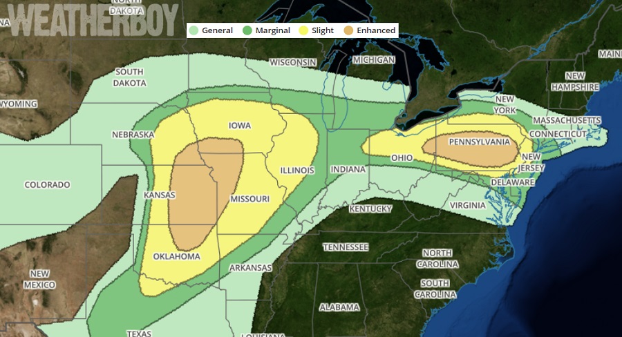
Severe storms capable of large hail, damaging wind and tornadoes are possible Tuesday from the central and southern Plains eastward to the Midwest. Severe storms with large hail, damaging wind and a couple of tornadoes are also possible from the Ohio Valley into a portion of the Northeast States Tuesday afternoon and early evening.
A low-amplitude shortwave trough will move off the northeast coast Tuesday morning, while upstream, a more significant upper trough will move into the central Plains before continuing northeast into the upper Mississippi Valley region Tuesday night. By Tuesday morning, the surface pattern should be characterized by a warm front from eastern Pennsylvania northwest to a surface low over the Great Lakes. A cold or stationary front will trail southwestward from this low to another area of low pressure over the central Plains. A dryline will extend southward from the central Plains low through western Kansas and western Texas. Meanwhile, an area of rain and thunderstorms developing within a zone of isentropic ascent on the cool side of a warm front and in association with a low-amplitude shortwave trough, will move through a portion of the Northeast early in the day. According to the National Weather Service’s Storm Prediction Center, storms will likely initiate along the stationary front as well as lake breezes and spread southeast through the warm sector.
The two areas with the greatest threat of severe weather are Kansas/Oklahoma/Missouri/Iowa/Nebraska/Illinois/Arkansas and Ohio/Pennsylvania/New Jersey/New York/Maryland. In these area, severe thunderstorms will form, with some becoming violent. The storms in the Midwest have a better chance of developing tornadoes in addition to damaging winds and large hail. In the northeast, especially Pennsylvania and Ohio, tornadoes will also be possible, albeit at lower odds.
People in the areas should be ready to act should the National Weather Service issue Tornado Warnings or Severe Thunderstorm Warnings on Tuesday.
