• Skip to primary navigation
  • Skip to main content
  • Skip to primary sidebar

Weatherboy

Weatherboy Weather News, Maps, RADAR, Satellite, and Forecasts.

  • Local
  • Earth Science News
  • RADAR
  • Current Warnings
  • Satellite
  • Current Maps
  • Forecast Maps
  • Video

Short-Term Heat Blast Heads to Northeast

by Weatherboy Team Meteorologist - June 16, 2018

Forecast high temperatures for Sunday, June 17; temperatures will be warmer on Monday, June 18, while humidity levels will make it feel even warmer. Image: weatherboy.com


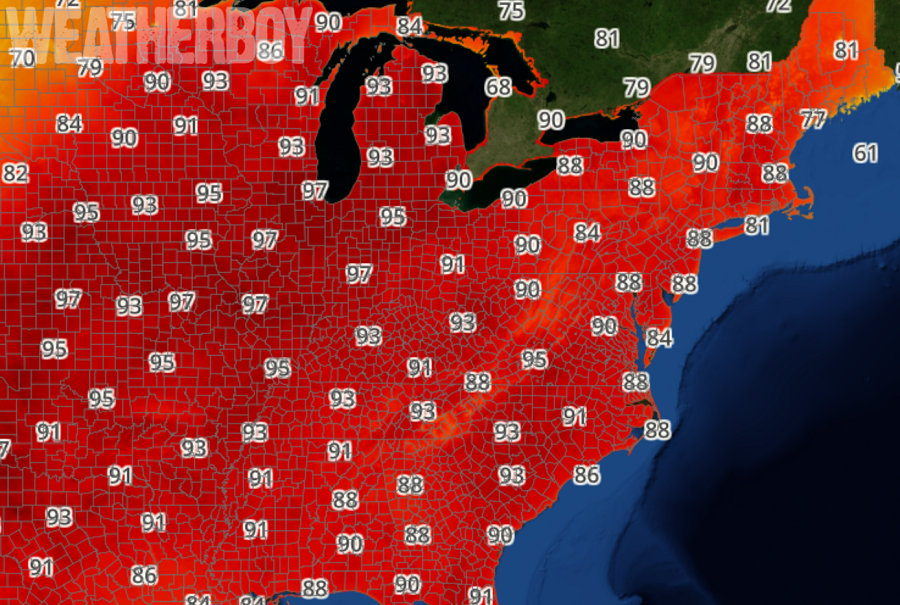
A summertime blast of heat and humidity will be moving into the northeast over the next 2 days, but the impact will be relatively short-lived. After a pattern that’s brought cooler than normal temperatures coupled with above-normal rain, it looks like Mother Nature will be turning up the heat, at least on a temporary basis.

People should know the difference between Heat Exhaustion and Heat Stroke. Image: National Weather Service

High pressure will remain offshore of the east coast on Sunday, setting up strong return flow and allowing temperatures to continue to rise throughout the northeast. Humidity values will also rise in addition to the temperatures, however, heat index values will only reach into the low 90s for Sunday.  It appears a surface trough will develop across the Mid Atlantic, possibly creating an area of instability with showers and storms over Virginia and North Carolina. It’s possible, although odds are low, some of that shower and storm activity could push into Maryland or Delaware too.


High pressure is forecast to remains anchored off the Southeast U.S. coast into the middle of the week. A hot and increasingly humid air mass will build in from the south and west on Monday. This sticky air mass will remain in place for Tuesday, although a cold front should push from north to south during the day. Cooler, but still mild conditions will return on Wednesday.

Primary Sidebar

Sponsored Ad

Search

Latest News

  • NOAA Flips the Switch On New Supercomputers for Weather and Climate Models
  • Cruise Ship Strikes Iceberg Off Alaska Coast, Sinking Dream Vacation Plans
  • Hurricane Bonnie on the Way; Several More Tropical Cyclones Possible; Warnings Now Issued
  • Black Bear Dies Trapped in Hot Car
  • Several Earthquakes Rattle South Carolina This Weekend as Mysterious Swarm Continues
  • For One Meteorologist, the Weather is a Drag
  • High Chance that Bonnie is on the Way in the Atlantic
  • Two Systems being Monitored by the National Hurricane Center for Possible Development
About | Careers | Contact | Contests
Terms | Privacy | Ad Choices
Weatherboy is a (R) Registered Trademark of isarithm LLC, All Rights Reserved.
All content herein is Copyright by Isarithm LLC 1997-2022