• Skip to primary navigation
  • Skip to main content
  • Skip to primary sidebar

Weatherboy

Weatherboy Weather News, Maps, RADAR, Satellite, and Forecasts.

  • Local
  • Earth Science News
  • RADAR
  • Current Warnings
  • Satellite
  • Current Maps
  • Forecast Maps
  • Video

Significant Widespread Damaging Wind, Tornado Event Unfolding Now

by Weatherboy Team Meteorologist - December 15, 2021

Today's Convective Outlook from the National Weather Service's Storm Predicition Center shows a bullseye of severe weather over the midwest today and tonight. Image: NWS
Today’s Convective Outlook from the National Weather Service’s Storm Predication Center shows a bullseye of severe weather over the midwest today and tonight. Image: NWS

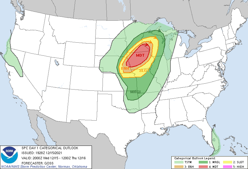
A significant, widespread, damaging wind and severe tornado event is unfolding now across a large portion of the Mid West, just days after a violent, record-breaking tornado outbreak occurred southeast of this region.


According to the National Weather Service’s Storm Prediction Center, widespread severe wind gusts of 60-75 mph along with at least a few tornadoes are likely from mid afternoon through early tonight across the Mid-Missouri Valley to the Upper Mississippi Valley. Embedded gusts of 75-100 mph and a strong tornado or two are also possible, particularly from extreme eastern Nebraska across western to northern Iowa and southeastern Minnesota.

A Tornado Watch is now in effect. Image: NWS

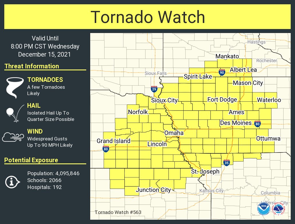
Due to these threats, the National Weather Service has issued a Tornado Watch across a broad area that includes portions of Iowa, Kansas, Minnesota, Missouri, Nebraska, and South Dakota until 8pm central time.

Many Tornado Warnings are also being issued for severe cells within this Tornado Watch. People are urged to take immediate action to protect their lives if a Tornado Warning is issued; they may only have moments to save themselves from extreme danger.


The National Weather Service is urging people to take action to save their lives and properties tonight. Image: NWS

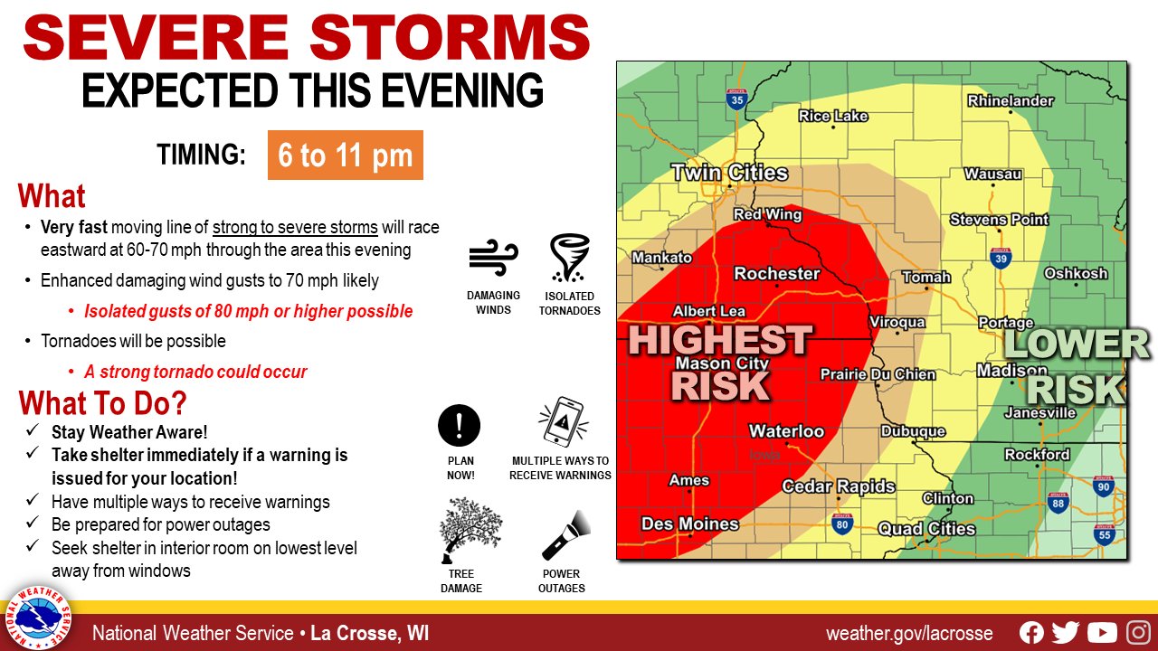
The National Weather Service is warning of the especially potent damaging wind gusts and violent tornado expected to peak between 6 and 11 pm this evening.

The storm system responsible for this severe weather is due to race north and east through the northern Great Lakes into southeastern Canada late tonight into tomorrow, bringing an end to the severe weather outbreak in the U.S.

Primary Sidebar

Sponsored Ad

Search

Latest News

  • Deadline for SBA Aid for Kauai Drought Coming Soon
  • Another Atmospheric River Event Slams into West Coast; More Epic Rain, Snow Expected
  • Anniversary of 1964 Great Alaskan “Good Friday” Earthquake and Tsunami
  • Tornado Watches, Warnings Issued as Severe Weather Impacts Louisiana, Mississippi, Alabama, & Gerogia
  • After Violent Night, Storms Shift to Ohio and Pennsylvania
  • Preliminary NTSB Report Shows Something other than Turbulence Killed Passenger on New England Flight
  • SEVERE Geomagnetic Storm Alert Issued; Massive Aurora On Display in North America
  • World’s Largest Volcano Quakes; No Tsunami Threat Around Hawaii
About | Careers | Contact | Contests
Terms | Privacy | Ad Choices
Weatherboy is a (R) Registered Trademark of isarithm LLC, All Rights Reserved.
All content herein is Copyright by Isarithm LLC 1997-2022