• Skip to primary navigation
  • Skip to main content
  • Skip to primary sidebar

Weatherboy

Weatherboy Weather News, Maps, RADAR, Satellite, and Forecasts.

  • Local
  • Earth Science News
  • RADAR
  • Current Warnings
  • Satellite
  • Current Maps
  • Forecast Maps
  • Video

Soaking Rain Storm Likely for the East

by Weatherboy Team Meteorologist - March 4, 2024

Rain will be especially heavy Wednesday night, as this American GFS computer forecast model depicts.  Image: tropicaltidbits.com
Rain will be especially heavy Wednesday night, as this American GFS computer forecast model depicts. Image: tropicaltidbits.com


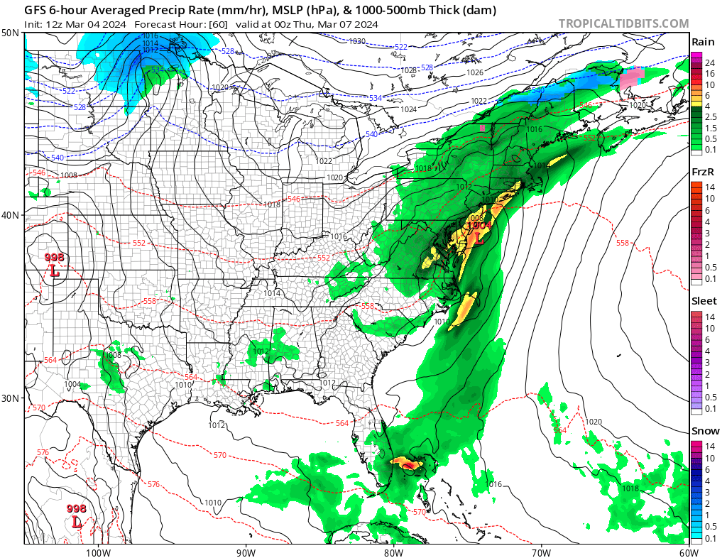
A soaking rain storm is unlikely to unfold in the eastern U.S. this week, impacting the Mid Atlantic and Northeast with two waves of significant rainfall. With cold air absent from the region, this will be an all-rain event with snow confined to central and northern Maine.

A wet weather pattern is in store for large areas of the lower 48 to the east of the Mississippi River over the next few days. This will be along and to the east of a slow moving frontal boundary stretching southwest to northeast from the Southern Plains into the Mid Mississippi Valley, Ohio Valley and into the Northeast and ahead of two areas of low pressure moving from the central Gulf coast up along the east coast. According to the National Weather Service, moisture values are expected to be much above average along and to the east of this front and ahead of the two areas of low pressure moving along the east coast, supporting the potential for widespread regions of precipitation.


Soaking rains are likely over the eastern U.S. in the coming days, with a widespread 2-3" rainfall expected over the Mid Atlantic through March 7. Image: NWS
Soaking rains are likely over the eastern U.S. in the coming days, with a widespread 2-3″ rainfall expected over the Mid Atlantic through March 7. Image: NWS

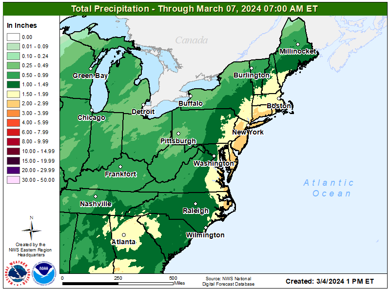
The heaviest rainfall totals expected from the central Gulf coast, across portions of the Southeast and Mid-Atlantic where the two areas of low pressure are expected to move across. The lead area of low pressure will spread rains across the Mid-Atlantic Monday night and into the Northeast on Tuesday. This will be followed by another low moving from the central Gulf coast Tuesday night, into the Southeast Wednesday and the Mid-Atlantic Wednesday night.

The heaviest rain is expected Wednesday night into early Thursday, with portions of New Jersey, Delaware, and eastern Pennsylvania and New York seeing the heaviest totals.


Primary Sidebar

Sponsored Ad

Search

Latest News

  • July to Start with Severe Weather Event in New Jersey, Pennsylvania, Delaware, & Maryland
  • Tropical Storm Barry Forms; Additional Storm Possible Near Florida
  • Severe Weather Threat & Tornado Risk Returns to Northeast Today
  • Hurricane Center Monitoring Possible Gulf Disturbance
  • Bolide Explodes over Southeastern United States; Piece Crashes into Home
  • 88 Earthquakes Strike Puerto Rico and Dominican Republic; No East Coast Tsunami Threat
  • Andrea Fades Away; No Other Tropical Cyclone Threats around US
  • Tropical Storm Andrea Forms Kicking Off the 2025 Atlantic Hurricane Season
About | Careers | Contact | Contests
Terms | Privacy | Ad Choices
Weatherboy is a (R) Registered Trademark of isarithm LLC, All Rights Reserved.
All content herein is Copyright by Isarithm LLC 1997-2022