Sally struck the Gulf Coast early this morning as a hurricane but is now just a tropical storm. Sally made landfall near Gulf Shores, Alabama as as a Category 2 Hurricane. Maximum sustained winds were at 105 mph at the time of landfall, just 6 mph shy of Category 3 status on the Saffir-Simpson wind scale. Now, Sally is a tropical storm with maximum sustained winds of 70 mph, just a few mph short of a Category 1 hurricane. While the winds remain strong, albeit not as strong as they once were, the big story continues to remain the epic rain that has fallen and will continue to fall over the area.
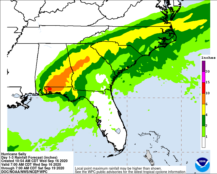
Historic and catastrophic flooding, including widespread moderate to major river flooding, is unfolding along and just inland from west of Tallahassee, Florida, to Mobile Bay, Alabama. Significant and widespread flooding is likely across inland portions of Alabama into central Georgia, and possible across western South Carolina, western and central North Carolina, and far southeast Virginia.
Some areas have already seen over 2 feet of rain and another 1-2 feet of rain is possible across a wide area.
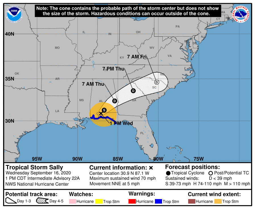
While the storm has moved inland, numerous warnings remain up. The Hurricane Warning from the Mississippi/Alabama border to the Okaloosa/Walton County line has been changed to a Tropical Storm Warning. While the Storm Surge Warning from Dauphin Island, Alabama, to the
Alabama/Florida border has been discontinued, it remains up from the Alabama / Florida border to the Walton / Bay County line in Florida. A Tropical Storm Warning remains in effect from the Mississippi /Alabama border eastward to Indian Pass, Florida.
A Storm Surge Warning means there is a danger of life-threatening inundation, from rising water moving inland from the coastline in the indicated locations. A Tropical Storm Warning means that tropical storm conditions are occurring within the warning area.
Right now, Tropical Storm Sally is moving toward the north-northeast near 5 mph, and a north-northeastward to northeastward motion at a slightly faster forward speed is expected this afternoon and tonight. A faster northeastward motion is forecast Thursday and Thursday night. On the forecast track, the center of Sally will move across the extreme western Florida panhandle and southeastern Alabama through early Thursday, move over central Georgia on Thursday, and move over South Carolina Thursday night.
Additional weakening is expected as the center moves farther inland this afternoon and tonight, and Sally is
forecast to become a tropical depression by Thursday morning.
