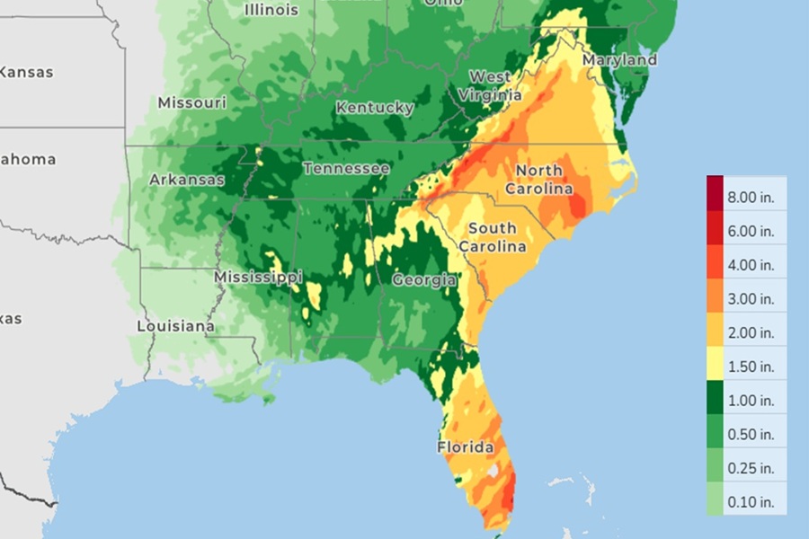
A soaker of a rainstorm is expected over the southeastern U.S. over the next 72 hours, with widespread rains of 3″ or more possible. Some areas could even see 5″ or more, especially over southeastern Florida, western North Carolina, and south-central North Carolina. A slow-moving storm system over the Southeast today will move slowly eastward/northeastward over the next two days. With a moisture feed from the south , locally heavy rain and thunderstorms are possible this evening/overnight and again Monday from the Florida Panhandle northward into Georgia and northeastward into the Carolinas.
According to the National Weather Service’s Weather Prediction Center, there is a Slight Risk (level 2 out of 4) of excessive rainfall through Tuesday for some areas — flash flooding is possible within and near the risk area. Temperatures will be cool in the Southeast due to abundant cloud cover but will modify as the system exits the region.
Scattered areas of flash flooding will be likely going through the early to mid-evening hours from locally slow-moving
and training showers and thunderstorms. tonight. The latest radar and satellite imagery shows an expansive area of heavy showers and thunderstorms impacting areas of central/eastern Georgia and through western/central South Carolina as a deep layer southerly conveyor belt of warm and moist air lifts into the Southeast U.S. and interacts with a stationary front draped west to east across southern Georgia and the South Carolina Lowcountry.
The deep layer moisture transport is well-defined around the eastern flank of a deep layer trough/closed low over the lower Mississippi Valley/western Gulf Coast region and has tropical origins with moisture advancing north up from Central America and the western Caribbean Sea across the eastern Gulf Coast region and into the Southeast U.S.
Some heavier showers and thunderstorms could be capable of producing rainfall rates of up to 1.5 to 2.5″/hour with the stronger convective cores, and especially with the efficient/moist deep layer tropical origins of the moisture transport.
With heavy rain expected in some southeastern cities, there could also be an urban flash flood threat. Major metropolitan areas well to the north including Atlanta, Georgia and Columbia, South Carolina could potentially see some urban flooding concerns from heavy rainfall over the next 24 to 48 hours.
