Spring 2018 begins at 12:15pm on Tuesday, but Old Man Winter isn’t leaving yet; a snowstorm will impact portions of the Mid Atlantic and Northeast, bringing yet another round of wind-whipped snow and coastal flooding to an area that has seen plenty in just March alone. The system responsible for the winter weather in spring is a complex low pressure system that’ll bring precipitation to the Mid Atlantic in two waves.
The first wave arrives late today, bringing light precipitation to the Mid Atlantic tonight into early tomorrow. While some light rain, snow, sleet, or a mix of all three are possible, this first wave will be the weakest of the two events. Nevertheless, it just takes a small amount of frozen precipitation to make for large travel headaches; always travel with care and caution on winter weather days.
A lull should exist during the day Tuesday, with most precipitation shutting off for some time during the day into the evening hours. During this lull, an area of low pressure will be deepening and strengthening off the Mid Atlantic coast, creating a larger precipitation shield than the first wave. It is this second wave that’ll have significant impacts.
The second wave arrives late Tuesday into Wednesday, with Wednesday being the core day of heavy snow. The snow will be of the heavy, wet nature; great for snowballs and snowmen, but difficult to easily shovel or blow. Unfortunately, heavy wet snow can also weigh down trees and wires that are already stressed by recent nor’easters. To make matters worse, there could be gusty winds which could add to the weather woes with additional power outages. And because this is a prolonged system with a steady on-shore flow beginning today and stretching into Wednesday night, coastal flooding will be a concern, especially in area prone to coastal flooding. Minor to moderate coastal flooding can be expected, especially at times of high tide.
In addition to heavy snow, this system will also be producing an area of sleet. These ice pellets can also make travel tricky on Wednesday, putting a quick icy coating on untreated surfaces. This sleet will be caused by a nose of milder air wrapping around the system well above the surface. Snowflakes melt in the milder air on their way down to the surface but refreeze as sleet, or ice pellets, when they re-enter the colder air before hitting the surface. Places that see sleet will see much less snowfall than surrounding areas that simply see plain snow.
Some computer forecast models are suggesting very heavy amounts of snow; while they paint a picture of a large area seeing 1-2 foot or more of snow, they’re being discounted to a degree. With spring here, snow will struggle to accumulate with a higher sun angle. The forecast models’ snow depictions also don’t factor in non-snow frozen precipitation into their tallies; sleet will “eat up” a lot of available moisture which will lead to less snow. Nevertheless, this is a robust weather system and other storms like it even later in March and early April have lead to hefty snowfall accumulations too.
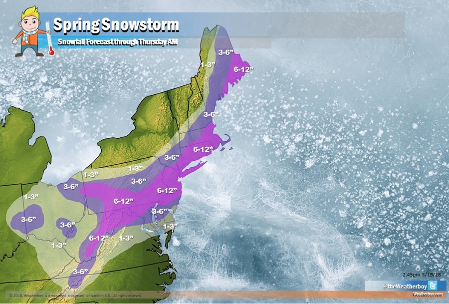
Based on the latest data evaluated, the area of heavy accumulation snow has expanded north to now include the New York City metro area and southern New England. It is important to point out that there will be a be a very sharp cut-off of snowfall on the northwestern edge of this storm; while amounts near a foot are possible in New Jersey, little to no snow will fall in places like Upstate New York.
The snow will wrap-up from southwest to northeast late Wednesday across the Mid Atlantic and southern New England, and by early Thursday for northern New England. We expect 6-12″ of snow in Philadelphia, PA, New York City, NY, and Boston, MA. We expect much less north and west of those areas. South and east, we expect 3-6″ in places like Washington, DC, Baltimore, MD, and Atlantic City, NJ. Even less is expected in Cape May County, NJ, Delaware Beaches, and the Eastern Shore of Maryland; there, a slushy coating is expected with a wintry mix of precipitation keeping totals lower there.