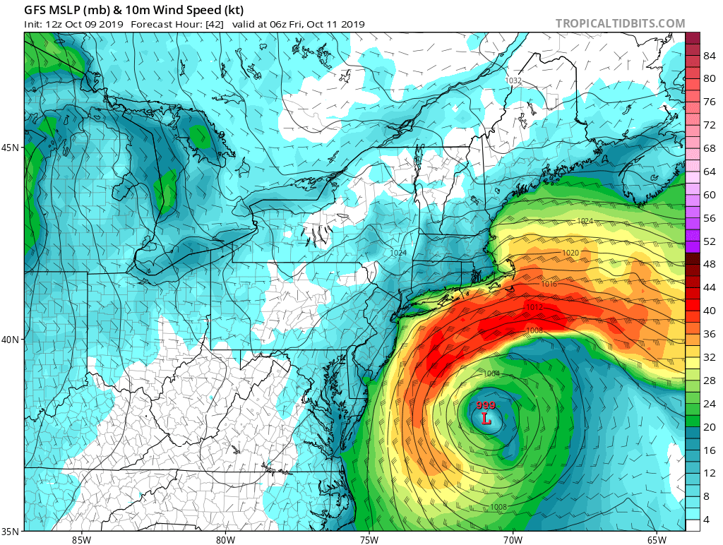
An organizing storm system located off the U.S. East Coast will bring coastal flooding and wind-whipped rains to portions of the Mid Atlantic and New England coasts. The greatest impacts will be between Virginia and Massachusetts.
For now, the National Hurricane Center doesn’t expect this system, which is really two merging into one, to become a tropical cyclone. Cloudiness and showers located off the mid-Atlantic coast of the United States are associated with a non-tropical area of low pressure that is producing gale-force winds. This system is forecast to strengthen as a non-tropical low off the east coast of the United States during the next day or so. Environmental conditions are expected to be unfavorable for significant subtropical or tropical cyclone development through the end of the week as it meanders offshore the United States. Regardless of development, this system is expected to bring strong winds, coastal flooding, and rough surf to portions of the mid-Atlantic and northeastern United States coasts through late week. The elongated area of low pressure located a few hundred miles southeast of Cape Hatteras, North Carolina that has also been tracked by the National Hurricane Center is becoming poorly defined. Upper level winds remain only marginally favorable for some additional development today. By tonight, the system is forecast to merge with the low off the east coast of the United States, creating the single coastal storm.
With week steering currents, the low pressure system forming will be anchored offshore of the Mid Atlantic region through the end of the week. This low will pinwheel offshore of New Jersey and Delaware through Friday, shifting a little each day, but not significantly until Saturday as a cold front approaches the area. With the low being offshore of the area, and strengthening at times, winds will be gusty across portions of the Mid Atlantic and southern New England, reaching 25-35 mph, with coastal areas possibly reaching 35-40 mph at times Thursday through Friday.
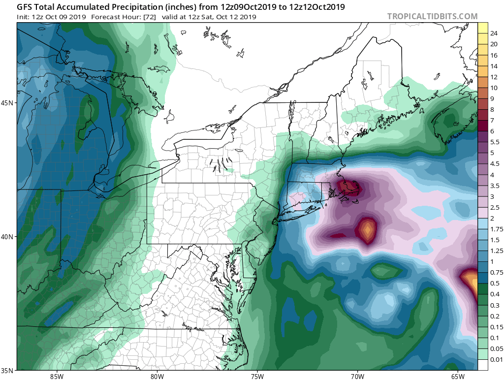
Because the storm system center is forecast to remain off-shore, most precipitation is expected to remain off-shore too. However, southeastern New England, especially the Cape Cod area, could see heavy rain, with more than 5″ possible from now through Saturday afternoon. Farther west, less rain will fall, with less than a quarter inch expected west of I-95 in New Jersey and I-87 in New York State.
In addition to rain and wind, the prolonged northeast to easterly winds on the Mid Atlantic and New England coasts will create rough surf, rip currents, beach erosion, and coastal flooding. With the threat of coastal flooding, the National Weather Service has begun to issue coastal flood advisories for portions of Virginia, Maryland, Delaware, New Jersey, New York, Rhode Island, and Massachusetts.
As we go into Saturday, a cold front will be approaching the area from the west, which will help push the low pressure out to sea. The front will finally move across the region being impacted by the coastal storm overnight Saturday into Sunday morning. There will be a chance of showers associated with the front, although the moisture and lift associated with the front weaken as it moves eastward. As such, most precipitation will fall from the coastal storm, not the frontal system that’ll boot it out to sea.
The front will push offshore and south of the northern Mid Atlantic through Sunday, and most areas will be dry as weak high pressure may affect the northeast. However, an area of low pressure may develop in the central and southern Mid Atlantic along the boundary, bringing rain just to the south of Delaware Sunday night into Monday. The rest of the northeast will remain dry into Monday.
