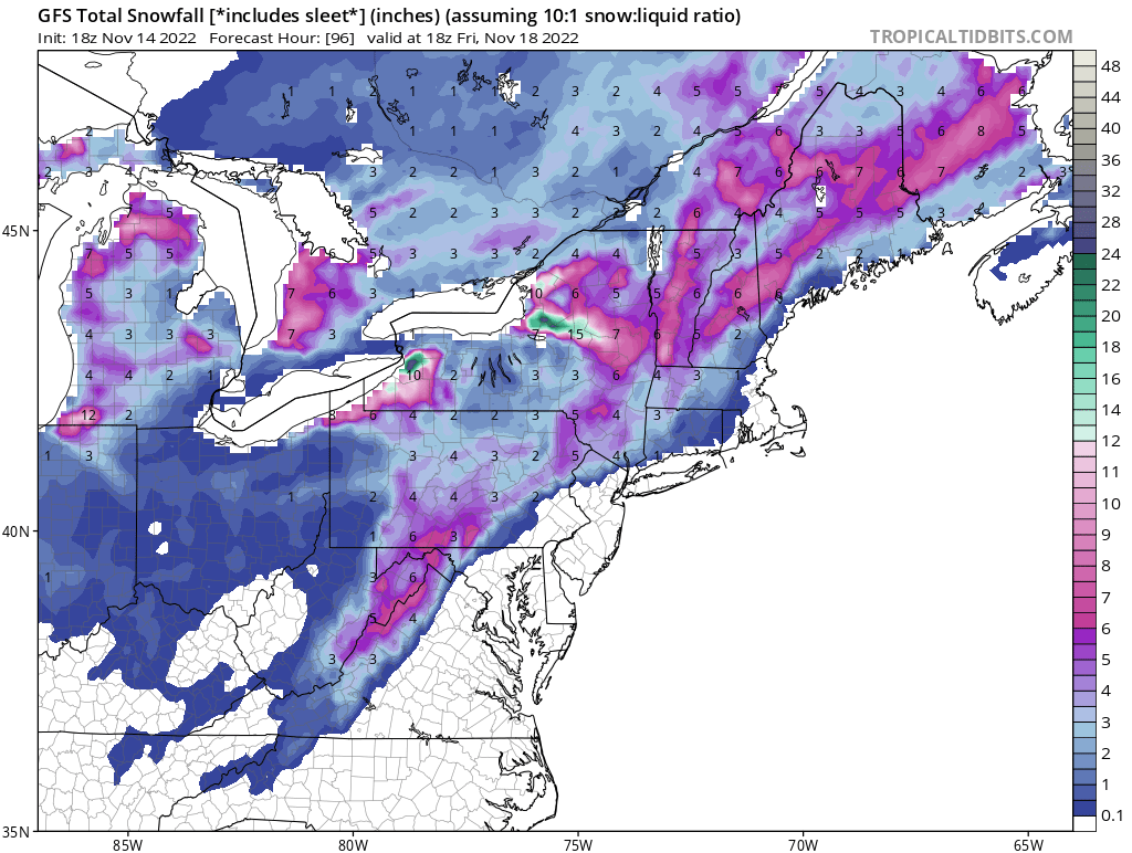
A substantial snowstorm is becoming likely for portions of the northeast in the coming days; 1-2 feet or more of snow is possible in portions of New York, with lighter amounts possible elsewhere from Pennsylvania and New Jersey north and east to Maine. Due to the threat of accumulating heavy snow, the National Weather Service has already posted Winter Storm Watches for some communities.
The National Weather Service is warning that potential remains for a significant long duration lake effect snow event Thursday night through much of the weekend. “There is still considerable uncertainty in exact band placement and amounts, but multiple periods of heavy snow are possible, including across the Buffalo metro area,” the National Weather Service warns.
A variety of meteorological ingredients will come together to produce light snow around the northeast and significant snow down-wind of the Great Lakes in Upstate New York. A deep trough is forecast to dig across the north-central Plains and western Great Lakes tomorrow. Precipitation chances will begin increasing from south to north Tuesday afternoon, with wet weather likely moving in to start. On Wednesday into Thursday, a split flow over the Lower Great Lakes and Mid Atlantic region will try to phase over New England during this period; according to the National Weather Service, this will lead to an early season “Miller B” type of cyclogenetic event. This will produce a light but measurable snowfall across the interior northeast; it’s also possible a wintry mix will fall from the Finger Lakes south and east into New York City’s far northwestern suburbs. Deeper moisture within the cyclonic flow on the backside of the exiting surface trough will support some light snow showers over the region Wednesday night, but more importantly, it will promote steadier lake-effect snows east and southeast of both Lake Ontario and Lake Erie.
For now, it looks like snow accumulations in the areas of lake effect snow bands will range from a couple of inches over Oswego county to 3-5″ along the Chautauqua ridge, with potentially more possible, particularly over the Chautauqua county. A shortwave ridge will pass across the Lower Great Lakes on Thursday, helping generate steady lake-effect snows across much of the Southern Tier and also Oswego county.

From Thursday night through next Monday, the National Weather Service says there’s high confidence that a prolonged southwest flow lake effect snow event will take place during this period. A deep longwave trough, featuring a vertically stacked low in the vicinity of Hudson Bay, will keep a flow of seasonably cold air in place over the Lower Great Lakes through the weekend to trigger a lake effect response. The National Weather Service says that a consensus of both ensemble and deterministic guidance packages are in fairly strong agreement of a southwest flow, but placement of accumulating snow bands will have to be further defined as the event nears.
In the wake of a passing shortwave ridge on Thursday, subtle troughing embedded within in the larger scale longwave pattern will produce a deep southwest flow of cold air across Lakes Erie and Ontario. On Thursday night and Friday, the flow is forecast to back a bit which will send well organized lake snow plumes across the Buffalo and Watertown metro areas and potentially into the northern suburbs.
Due to these things coming together, the National Weather Service has begun to issue Winter Storm Watches for Thursday evening through Sunday evening for a potential high impact, long duration lake snow event. If winds back further for longer period of time, they may extend watches to Niagara and Orleans counties too.
While no accumulating snow is expecting in the I-95 corridor from Philadelphia to Boston from this week’s weather, that could change around and just after Thanksgiving. Some extended range guidance is suggesting significant, heavy snow could extend into the Mid Atlantic and out to the coast, including the I-95 corridor. While there could be several inches of snow in the I-95 corridor, a foot or more could fall in inland locations. It is too soon to tell whether that snow will materialize, but it’s clear the overall weather pattern is trending colder and stormier for the northeast over the next 1-2 weeks.
