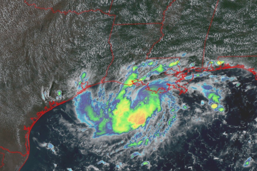
Texas and Louisiana are bracing for a direct hit by a compact storm; ahead of the storm, the National Hurricane Center issued Tropical Storm Watches for the coast. The storm system was classified as a potential tropical cyclone this morning and upgraded to a Tropical Depression this afternoon. It is expected to become a Tropical Storm soon and could even become a category 1 hurricane before impacting the norther central Gulf of America coastline.
Right now, a Storm Surge Watch has been issued for a portion of the northwestern Gulf Coast while a Tropical Storm Warning has been extended east along the coast of Louisiana now too. With these changes, a Tropical Storm Warning is now in effect from Port Bolivar, Texas to the Vermilion/Iberia Parish line in Louisiana. The Storm Surge Watch is now up from High Island, Texas to the Vermilion/Cameron Parish Line in Louisiana.
A Tropical Storm Warning means that tropical storm conditions are expected somewhere within the warning area, in this case within the next 24 hours or so.
A Storm Surge Watch means there is a possibility of life-threatening inundation, from rising water moving inland from the coastline, in the indicated locations during the next 48 hours.
As of the latest advisory from the National Hurricane Center, the system was located about 105 miles south of Morgan City, Louisiana and about 185 miles southeast of Port Arthur, Texas. Maximum sustained winds are 35 mph while the minimum central pressure is down to 1011 mb or 29.86″.
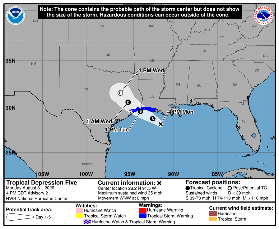
According to the latest forecast from the National Hurricane Center (NHC), the storm will continue its west-northwestward to northwestward motion during the next couple of days. On the forecast track, the center of the system is predicted to reach the northwestern Gulf Coast within the warning area on Tuesday and move inland over southeast Texas on Tuesday night.
Strengthening is expected, and the depression is likely to become a tropical storm this evening. Once it becomes a named storm, it would be called Edouard.
Some forecast data suggests the storm could rapidly intensify in the little time it has before it hits land and hitting land as a strong tropical storm or a low-level hurricane remain within the realm of possibilities.
While potent, the storm is very small. Impacts from the strongest winds will only be felt over a very narrow corridor as the storm moves ashore.
Tropical storm conditions are expected to reach the coast within the warning area by Tuesday morning, making outside preparations difficult or dangerous. People should rush their preparations to completions now.
The combination of storm surge and tide will cause normally dry areas near the coast to be flooded by rising waters moving inland from the shoreline. The water could reach 2-4 feet from High Island, Texas to the Vermilion/Cameron Parish Line in Louisiana and up to 1-3 feet from the Vermilion/Cameron Parish Line, Louisiana to Morgan City, Louisiana. The deepest water will occur along the immediate coast near and to the right of the center. Surge related flooding depends on the relative timing of the surge and the tidal cycle, and can vary greatly over short distances.
Very heavy rain is possible with maximum totals of 9 inches for parts of the Upper Texas Coast inland through east-central Texas, with the potential for 2 to 3 inches in far Southwest Louisiana. This rainfall is likely to produce flash flooding, especially in low-lying and urban areas. River flooding may also be possible.
