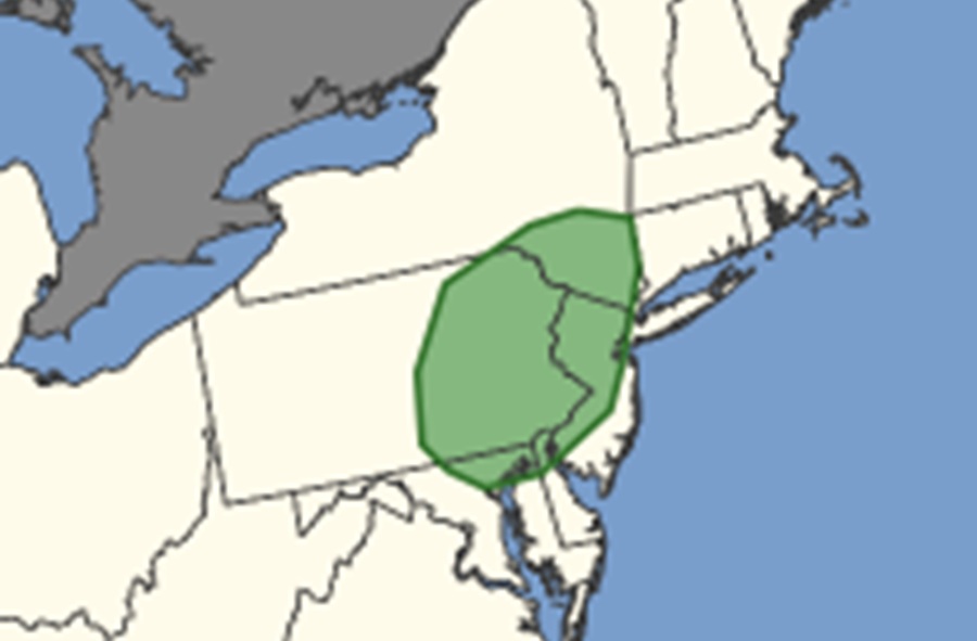
Severe weather is expected in portions of the Northeast and Mid Atlantic today and the National Weather Service’s Storm Prediction Center (SPC) has expanded the area where they believe there is an elevated threat of tornadoes in today’s storms. The expanded area includes a larger part of eastern Pennsylvania, northeastern Maryland, northern Delaware, much of northern, central, and southwestern New Jersey, and southeastern Upstate New York.
“Thunderstorms capable of producing damaging winds and perhaps a tornado or two are expected across parts of the Mid-Atlantic into southern New England, mainly this afternoon and early evening,” warns the SPC in their latest Convective Outlook issued this morning for today.
Recent water vapor satellite imagery shows a prominent and positively tilted upper trough extending from eastern Canada into the Upper Midwest. This upper trough will advance eastward while amplifying over the eastern U.S., with enhanced west-southwesterly low/mid level flow expected to overspread much of the Mid-Atlantic and Northeast.
A related surface low over southern Ontario will develop east-northeastward today into southern Quebec, as a trailing cold front sweeps east-southeastward across the eastern states. Low-level moisture is forecast to gradually increase ahead of the front through the afternoon, while atmospheric instability will gradually increase today with as daytime heating grows.
The SPC says that favorable deep-layer shear will support some updraft organization setting the stage for potentially violent weather conditions. Given the strength of the low/mid-level flow, isolated strong/gusty winds may occur this morning with ongoing convection along/near the front across western Pennsylvania and New York, even though instability remains very limited.
The SPC also says that the latest short-term guidance continues to suggest that a low-topped
convective line will further develop across central into eastern Pennsylvania and southern New York this afternoon.
“Convectively augmented wind gusts capable of producing scattered damaging winds will likely be the main severe risk as this activity spreads quickly eastward across the northern Mid-Atlantic and southern New England through early evening,” cautions the SPC. They add, “The greatest coverage of damaging winds should focus across parts of eastern Pennsylvania into New Jersey and southern New York, where locally greater instability is forecast.”
According to the SPC, the potential for line-embedded mesocirculations is less clear. While some low-level shear will be present, the enhanced low-level flow is forecast to gradually veer to west-southwesterly through the afternoon/evening, which may reduce effective storm relative helicity somewhat.
“Still, at least an isolated threat for damaging winds and perhaps a tornado should spread towards the coast before convection weakens this evening due to marine layer influences and nocturnal cooling,” warns the SPC.
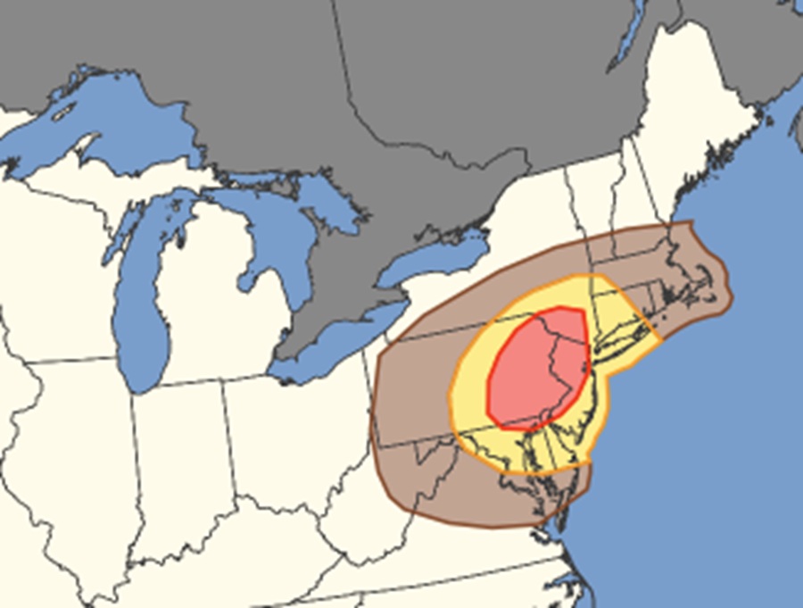
While the focus area of tornadic activity is over a limited portion of New Jersey, New York, Pennsylvania, and surrounding areas, the threat zone for damaging winds is over a larger area.
According to the SPC, the area that is the bullseye for tornadic activity is also the bullseye for damaging wind gusts. But the area that could see damaging winds is much broader and includes all of Maryland, New Jersey, Delaware, Connecticut, Massachussetts, and Rhode Island, along with portions of Vermont, New Hampshire, Maine, New York, West Virginia, and Virginia. All but far northwest Pennsylvania is included in a damaging wind threat zone in the Keystone State.
