
According to USGS, three relatively weak earthquakes struck eastern Tennessee over the last 24 hours. These earthquakes bring the total number to 9 of earthquakes this part of Tennessee has seen in the last 30 days.
The first earthquake struck last night at 9:06 pm near Sweetwater; the second earthquake struck 1 hour 16 minutes later in the same exact spot. Both earthquakes had an epicenter with a depth of 15.6 km; the first earthquake was a magnitude 1.8 event while the second was only 1.7.
The third earthquake of the series hit today at 6:09 am near Vonoroe, not far from the earlier two. This latest earthquake struck from a depth of 16.3 km and had a stronger magnitude at 2.0.
There have been no reported injuries or damage from any of these earthquakes.
In the last 30 days, the strongest earthquake hit near Bean Station, not far from these recent quakes. The Bean Station quake was measured as a magnitude 2.4 event.
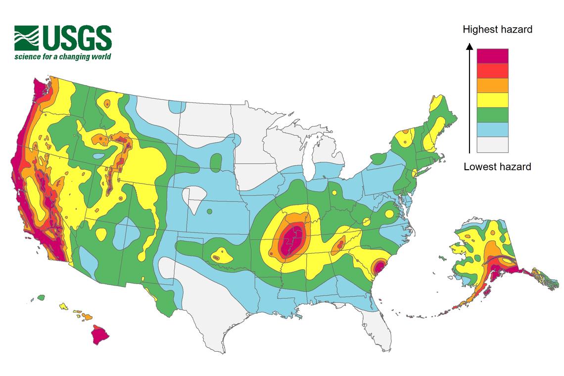
The activity in eastern Tennessee appears independent of the more frequent activity impacting the western portion of the state, which is near the New Madrid Seismic Zone. The New Madrid Seismic Zone, or NMSZ for short, has a violent history that experts say will repeat itself, although no one is sure when it’ll happen. The New Madrid Seismic Zone has had 38 earthquakes in the last 30 days and only 4 in the last week.
December 16 marks the anniversary of the first of three major quakes to strike the United States during the winter of 1811-1812, a violent time in seismological history of the region that scientists say will be repeated again.
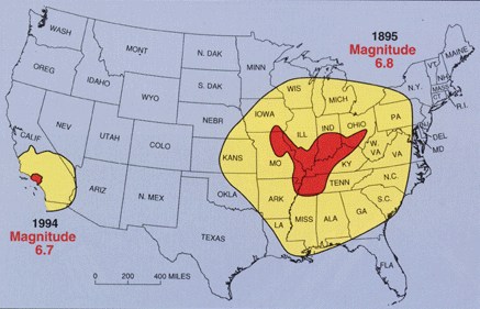
While the US West Coast is well known for its seismic faults and potent quakes, many aren’t aware that one of the largest quakes to strike the country actually occurred near the Mississippi River. On December 16, 1811, at roughly 2:15am, a powerful 8.1 quake rocked northeast Arkansas in what is now known as the New Madrid Seismic Zone. The earthquake was felt over much of the eastern United States, shaking people out of bed in places like New York City, Washington, DC, and Charleston, SC. The ground shook for an unbelievably long 1-3 minutes in areas hit hard by the quake, such as Nashville, TN and Louisville, KY. Ground movements were so violent near the epicenter that liquefaction of the ground was observed, with dirt and water thrown into the air by tens of feet. President James Madison and his wife Dolly felt the quake in the White House while church bells rang in Boston due to the shaking there.
But the quakes didn’t end there. From December 16, 1811 through to March of 1812, there were over 2,000 earthquakes reported in the central Midwest with 6,000-10,000 earthquakes located in the “Bootheel” of Missouri where the New Madid Seismic Zone is centered.
The second principal shock, a magnitude 7.8, occurred in Missouri weeks later on January 23, 1812, and the third, a 8.8, struck on February 7, 1812, along the Reelfoot fault in Missouri and Tennessee.
The main earthquakes and the intense aftershocks created significant damage and some loss of life, although lack of scientific tools and news gathering of that era weren’t able to capture the full magnitude of what had actually happened. Beyond shaking, the quakes also were responsible for triggering unusual natural phenomena in the area: earthquake lights, seismically heated water, and earthquake smog.
