After a rough night in portions of the Midwest last night, another round of thunderstorms are firing up today with new thunderstorm threats shifting East. The National Weather Service’s Storm Prediction Center has updated their latest Convective Outlook which reflects what areas in the nation are most likely to see severe storms. The official definition of a “severe” storm according to the National Weather Service is a thunderstorm with winds of 58mph or greater, hail one inch in diameter or larger, or a tornado. Severe thunderstorms can also contain heavy rains which may cause flash floods or frequent lightning which could be deadly, but rain and lightning alone are not characteristics to a severe storm alone.
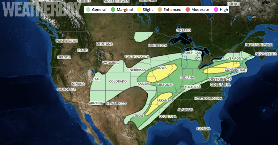
The greatest threat of severe weather today exists over three primary areas. The first is over southern New Hampshire and Vermont, western Massachusetts, northwestern Connecticut, southern Upstate New York, northern Pennsylvania, and northeastern Ohio. The second is over southern Iowa, northwestern Illinois, northern Missouri, northeastern Kansas, and southeastern Nebraska; this area was also hit hard last night. The third area is over Arkansas, southeastern Oklahoma, and northeastern Texas. Strong to severe thunderstorms are also possible across a broader area that stretches from south Texas to southern New Jersey north into central New England and west to the Rockies.
People in the severe weather risk zones should keep an eye to the sky and an ear to updates from the National Weather Service should any Severe Thunderstorm or Tornado watches or warnings be issued. When a Severe Thunderstorm Warning or Tornado Warning is issued, you may only have moments to take action prior to the arrival of life-threatening weather.
