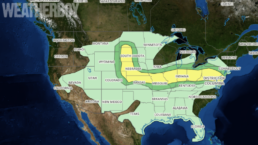
Severe weather center over the Upper Midwest today will spread east tomorrow, with a broad area of severe weather expected. Within that area of severe weather, isolated tornadoes are possible too. The greatest threat of tornado development is over eastern Ohio, the southern half of Pennsylvania, central and southern New Jersey, almost all of Delaware, much of Maryland, extreme northern Virginia, and northern West Virginia.
According to the National Weather Service’s Storm Prediction Center, a belt of strengthening westerlies over the northern Plains will influence an area of disturbed weather across the middle of the country into Wednesday afternoon and night. Severe thunderstorms will initially be possible across the north-central High Plains Wednesday afternoon in vicinity of a prefrontal trough of low pressure and also a southeastward-moving front. This severe weather area includes western South Dakota and portions of North Dakota and Nebraska. At least isolated supercells are expected across these regions with large hail and strong wind gusts probable. Meanwhile, a low-amplitude shortwave trough and a related belt of strong winds aloft will stretch over a south to southeastward spreading front. Storms will likely increase/intensify through early/mid afternoon near the effective front. Elsewhere in the Midwest including Missouri to Ohio, the boundary layer should become moderately to strongly unstable Wednesday afternoon along and south of a southward-advancing front, with widely scattered deep convective development likely through the afternoon. Here, the threat of damaging hail and winds will also exist.

To the east towards the Mid Atlantic, storms will likely increase in coverage and intensity through the early and mid afternoon hours near the front. According to the Storm Prediction Center, atmospheric conditions appear to be able to support some initial supercells along with well-organized southeastward-moving clusters. Because of these dynamics, damaging winds and severe hail are expected. Although low-level winds will tend to remain veered in areas near and south of the front, moderately strong low-level shear could produce a tornado risk during the afternoon and early evening hours for some.
For now, the greatest threat of tornadic cells is during the afternoon and early evening hours in portions of the Mid Atlantic. Central and southern New Jersey, much of Delaware, northern Maryland, Virginia, and West Virginia, the southern half of Pennsylvania, and portions of Ohio face the greatest threat of tornadoes. While most won’t see a tornado in this area, their presence can’t be ruled out due to the atmospheric ingredients coming together on Wednesday.
