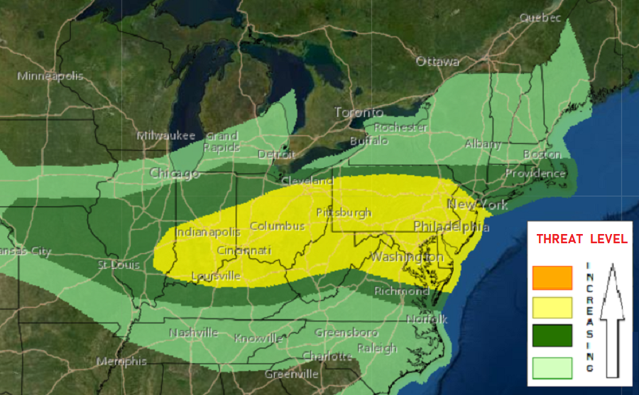
Tornadoes, wind damage, and destructive hail are all possible in portions of the Ohio River Valley and Mid Atlantic on Thursday in an expected severe weather outbreak. The greatest threat of violent weather is across Pennsylvania and New Jersey, where the National Weather Service’s Storm Prediction Center (SPC) has the area identified at risk for tornadic thunderstorms. Severe storms are also expected across portions of Indiana, Kentucky, West Virginia, Ohio, Virginia, Maryland, and Delaware. The cities of Washington, DC, Baltimore, MD, Philadelphia, PA, and New York City, NY are included in the area at highest risk of seeing severe weather.
According to the SPC, showers and thunderstorms will likely be ongoing Thursday morning across the southern Great Lakes in association with a mesoscale convective vortex. A mesoscale convective vortex, or MCV for short, is an area of low pressure within a mesoscale convective system that pulls winds into a circling pattern. MCVs generally have a core thats 30-60 miles wide and 1-3 miles deep; it is within these MCV’s that the most violent weather could occur.
Tomorrow, in the lower levels of the atmosphere, a surface low initially over the central Great Lakes will develop eastward into New England by late Thursday night. An attendant cold front will push southeast across a large part of the Ohio Valley, with the trailing portion of the boundary extending into the central High Plains. Meanwhile, a moist airmass will extend from the Corn Belt eastward into the Mid-Atlantic states with high dewpoints around 60-70. The SPC says that strong heating on the periphery of earlier cloud debris will result in a “moderate to very unstable airmass”. This unstable airmass should help trigger several linear clusters or a combination of linear clusters and supercells from the Ohio Valley into the Mid Atlantic region.
The SPC says that damaging wind gusts and tornadoes are possible with more intense thunderstorms expected to pop-up during the day. In addition to isolated flash flooding and frequent hazardous lightning strikes, damaging wind gusts and damaging large hail are also possible from these potent storms.
People across this area are urged to keep an eye to the sky and an ear to the National Weather Service; severe weather alerts may be required for portions of this region during the day on Thursday. While destructive thunderstorms are possible, the National Weather Service’s Wireless Emergency Alert system isn’t ready yet to issue wireless alerts. That new system will go live on August 2.
