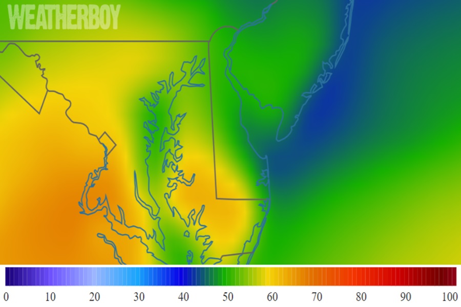
Just days after an area of low pressure blanketed the region with a light snowfall, it appears a touch of spring is about to visit the Mid Atlantic, with high temperatures near 70 possible in portions of the northern Mid Atlantic on Friday. In addition to being mild, despite the calendar saying it’s the end of January, it will also be very humid for this time of year.
An approaching frontal system is responsible for the brief touch of spring conditions expected in the Mid Atlantic. On Thursday, low pressure will continue to lift across the eastern Great Lakes while its associated cold front begins to approach the region from the northwest. Meanwhile, the upper ridge bringing calm conditions to the region today will be slowly nudged farther offshore by the lead shortwave emanating from the longwave trough lingering over the plains.
With this type of atmospheric set-up, a deep-layered south to southwest flow will prevail, pumping unseasonably mild weather north into the Mid Atlantic from the south.

By Thursday night, the surface low is forecast to move north and east across the eastern Great Lakes towards western New England, dragging a weak cold front closer to the forecast area.
By Friday morning, very warm and anomalously humid conditions will persist ahead of the frontal passage with air temperatures rising into the 50s, 60s, and 70s while dewpoints climb into the 50s and 60s. Due to this, it’ll feel very spring-like Friday with high temperatures in the low to mid 70s for much of the central and southern Mid Atlantic. While it’ll only get into the 60s along the Eastern Shore of Maryland, temperatures will flirt with 70 as far north as Washington, DC. It won’t be as warm in Philadelphia and New York City, but temperatures even there will be well above normal ahead of the frontal passage.
Right now, it appears the cold front will cross the region later Friday afternoon into Friday night, bringing an end to the spring weather tease. The front should stall south of the region, allowing for a wave of moisture or two to move along the stalled front across the Carolinas Friday night, bringing increasing rain chances and the risk of isolated thunderstorms from south to north in the Mid Atlantic.
Once the front exits the region, conditions will return to more seasonable norms.