
The National Weather Service’s Storm Prediction Center (SPC) is warning of an enhanced threat of severe to potentially violent thunderstorms, destructive wind gusts, and isolated tornadoes in an area around New Jersey, eastern Pennsylvania and Maryland, Delaware, and northeastern Virginia.
Severe thunderstorms are expected across much of the Mid-Atlantic region this afternoon and evening, and to a lesser extent into the Carolinas and over portions of New England. According to the SPC, severe and damaging wind gusts are the primary concern while there’s also an isolated large hail and isolated tornado threat too.
A broad and low-amplitude shortwave trough is moving across the Great Lakes region and Ohio Valley today. Ahead of the trough, visible satellite imagery from GOES-East shows mostly clear skies from eastern New York and much of New England southward across the Mid-Atlantic region and the Carolinas. Very warm and moist conditions will develop by mid-afternoon setting the stage for significant atmospheric instability.
Scattered thunderstorms are expected by the SPC to develop, with the highest concentrations moving off the higher terrain of Pennsylvania, Virginia, and North Carolina tracking east across New Jersey, Delaware, and Maryland.

While there is a threat of large hail and isolated tornadoes in this region, the greatest threat is from damaging winds. Strong thunderstorm wind gusts are defined by the National Weather Service to be between 39 mph and 57 mph while “severe” wind gusts between 58 mph and 74 mph causing damage.
Damaging winds are often called “straight-line” winds to differentiate the damage they cause from tornado damage. Strong thunderstorm winds can come from a number of different processes. Most thunderstorm winds that cause damage at the ground are a result of outflow generated by a thunderstorm downdraft.
Light Damage to properties begins to occur with 65-85 mph winds; damage like loss of roofing material, broken tree branches, and some trees get uprooted with these speeds. Once winds exceed 86 mph, there is considerable roof damage, mobile homes are overturned, and light poles are bent. Stronger winds associated with tornadoes and hurricanes can do far worse damage, destroying even reinforced homes.

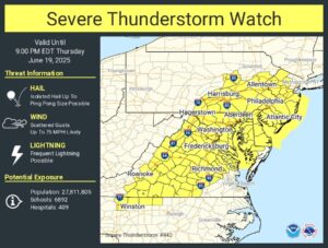
Due to the threat of severe thunderstorms, the National Weather Service has issued Severe Thunderstorm Watches from northern New York and Vermont south to Virginia, including portions of Pennsylvania, Maryland, Connecticut, and Massachussetts, and all of Delaware and New Jersey.
Severe Thunderstorm Watches are issued by the National Weather Service when conditions are favorable for the development of severe thunderstorms in and close to the watch area. A severe thunderstorm by definition is a thunderstorm that produces one inch hail or larger in diameter and/or winds equal or exceed 58 miles an hour. The size of the watch can vary depending on the weather situation. They are usually issued for a duration of 4 to 8 hours. They are normally issued well in advance of the actual occurrence of severe weather.
“During the watch, people should review severe thunderstorm safety rules and be prepared to move a place of safety if threatening weather approaches,” advises the National Weather Service.
Stay safe!https://t.co/aj4EUXzbgK https://t.co/8u7ifzd3wP
— the Weatherboy (@theWeatherboy) June 19, 2025
A Severe Thunderstorm Watch is issued by the Storm Prediction Center in Norman, Oklahoma. Prior to the issuance of a Severe Thunderstorm Watch, SPC will usually contact the affected local National Weather Service Forecast Office and they will discuss what their current thinking is on the weather situation. Afterwards, SPC will issue a preliminary Severe Thunderstorm Watch and then the affected NWFO will then adjust the watch (adding or eliminating counties/parishes) and then issue it to the public by way of a Watch Redefining Statement. During the watch, the local National Weather Service office will keep the public informed on what is happening in the watch area and also let the public know when the watch has expired or been cancelled.
A Severe Thunderstorm Warning is issued when either a severe thunderstorm is indicated by weather radar or a spotter reports a thunderstorm producing hail one inch or larger in diameter and/or winds equal or exceed 58 miles an hour; therefore, people in the affected area should seek safe shelter immediately. Severe thunderstorms can produce tornadoes with little or no advance warning. Lightning frequency is not a criteria for issuing a severe thunderstorm warning. Severe Thunderstorm Warnings are usually issued for a duration of one hour. They can also be issued without a Severe Thunderstorm Watch being already in effect. Severe Thunderstorm Warnings are issued by local National Weather Service Forecast Offices.
