After two significant coastal storms, the northeastern United States may be facing it’s third. While lingering snow shower activity persists in New England today from the last Nor’Easter, eyes are already on the next potential threat.
Before the next storm threat, high pressure will help calm conditions down in an area hit hard by two recent coastal storms. People in the northeast will be able to dig out Friday into Sunday from a storm that dropped more than 2′ in places; snow which fell as heavy as 3-6″/hr overwhelmed snow removal crews on Wednesday. A ridge of high pressure will settle across the region as an upper level low swings through. Overall, this will result in mostly dry weather and cooler than normal temperatures. When that upper level low swings overhead on Friday, some clouds will form and there’s a slight chance of a passing light snow or rain shower. But beyond that slight chance, conditions should remain dry and calm. Fair and dry weather is expected on Saturday.
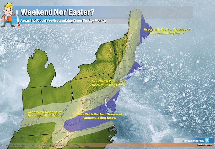
Beyond Saturday, all eyes will be on the next low pressure system. An area of low pressure will move across the Ohio Valley to the Mid Atlantic coast, re-intensifying as it hits the ocean. Some explosive growth of this storm is expected again, with a rapid deepening of low pressure, triggered more wind-whipped heavy precipitation. It is still too early to know with certainty where this storm will go; a track closer to the northeast coast would result in heavy precipitation in areas that saw that yesterday; a track more out to sea would spare most of the northeast, producing accumulating snow more south than where previous storms dropped snow.
Computer model forecast guidance that meteorologists use to aid in forecasting remains conflicted this afternoon; some guidance suggests a turn towards the north, while other suggests a more progressive solution out to sea. Clearly, each storm track scenario would lead to drastically different weather for the northeast on Sunday into Monday.
Until forecast confidence, which is low at this time, increases, it appears the best chance for heavier accumulating snow later Sunday into early Monday is across southern West Virginia, much of Virginia, the eastern shore of Maryland, most of Delaware, southern New Jersey, eastern Long Island, and extreme southeastern New England. Once additional data is analyzed later tomorrow, a clearer picture with the forecast will be possible. Until then, people in an area where there’s a chance of accumulating snow should prepare for that possibility, especially if they’re without power or under deep snow from the last two storms to impact the region.
