The National Hurricane Center is tracking Tropical Storms Cindy and Bret as they march towards land.
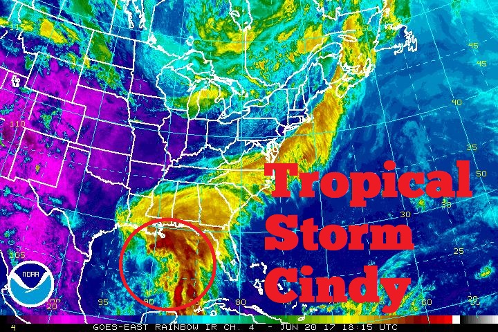
Tropical Storm Cindy is the latest system to be named by the National Hurricane Center. Previously known as the generic “Potential Tropical Cyclone #3”, the system is in the Gulf of Mexico. While the center of circulation is due to strike Texas, most moisture associated with this tropical cyclone is on its eastern side. This means even with a Texas landfall, the worst of the heavy rain from this system will be in Louisiana and over the Gulf coasts of Mississippi, Alabama, and Florida.

At 1pm CT today, satellite imagery, aircraft data, and surface observations indicate that the low pressure system in the central Gulf of Mexico had acquired a well-defined center which prompted its designation as Tropical Storm Cindy. The third tropical storm of 2017 has been stationary for the past few hours, but the system is expected to resume a motion toward the northwest at around 10 mph later today, and this motion is expected to continue through Wednesday night. A turn toward the north-northwest is forecast early Thursday. On the forecast track, Cindy is expected to approach the coast of southwest Louisiana late Wednesday or Wednesday night, and move inland over western Louisiana and eastern Texas on Thursday.
Maximum sustained winds are near 45 mph with higher gusts. Little change in strength is forecast before the system reaches the coast on Thursday. Tropical-storm-force winds extend outward up to 205 miles mainly to the north and east of the center. The estimated minimum central pressure is 999 mb (29.50 inches of Mercury).
A Tropical Storm Warning is in effect for High Island to the Mouth of the Pearl River while a Tropical Storm Watch is in effect for West of High Island to San Luis Pass.
A Tropical Storm Warning means that tropical storm conditions are expected somewhere within the warning area, in this case within the next 24 to 36 hours. A Tropical Storm Watch means that tropical storm conditions are possible within the watch area, generally within 48 hours.
Residents along the entire Gulf Coast from eastern Texas to western Florida should act on their Hurricane Action Plans now, preparing especially for heavy inland flooding.
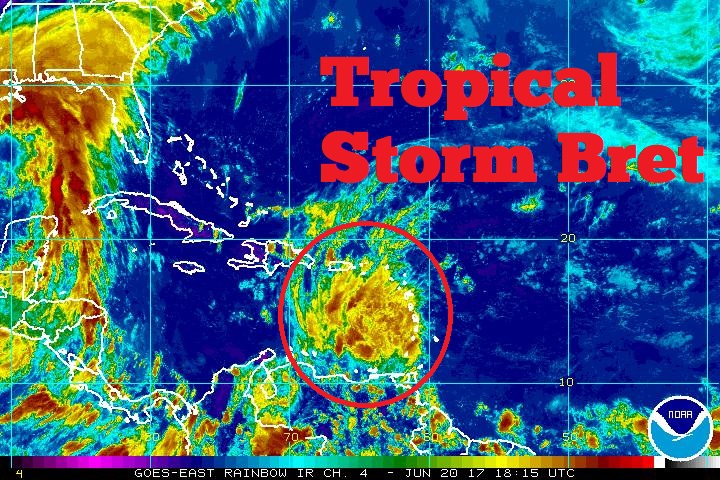
While Cindy churns in the Gulf of Mexico, Tropical Storm Bret is cruising along north of South America. At 200 PM AT, the center of Tropical Storm Bret was
estimated near latitude 11.6 North, longitude 66.2 West. Bret has increased its forward speed and is now moving between west and west-northwest near 23 mph and this general motion is
expected to continue through tomorrow. On the forecast track, Bret or its remnants will continue to move across the southeastern Caribbean Sea for the next couple of days.
Satellite images indicate that Bret is becoming disorganized while losing its closed circulation. Maximum sustained winds are near 40mph with higher gusts, and these winds are occurring well to the northeast and north of the center. Additional weakening should continue today, and Bret could degenerate into a tropical wave later today or Wednesday.
Tropical-storm-force winds extend outward up to 125 miles to the north of the center. The estimated minimum central pressure is 1009 mb (29.80 inches).
The ABC islands of Aruba, Bonaire, and Curacao remain under a Tropical Storm Watch.
