After a brief lull in tropical activity in the wake of Hurricane Laura which made landfall along the Louisiana coast as a strong category 4 hurricane last week, it appears Nana and Omar, the next two names on the list of 2020 Atlantic storm names, will be coming to life with tropical cyclone formation expected by the National Hurricane Center. If they form, they could break records as the earliest “N” and “O” storms on record in the Atlantic Hurricane Basin. The current record earliest 14th and 15th named storms are Nate, which formed on September 6, 2005, and Ophelia, which formed a day later on September 7, 2005.
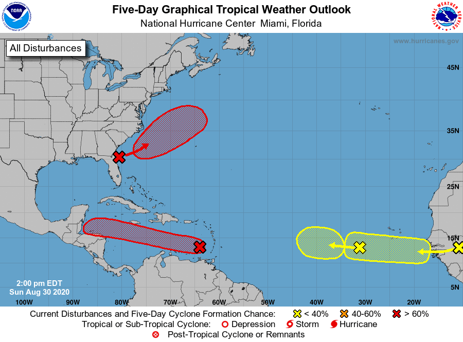
The first area of concern with the highest odds of tropical cyclone development is a westward-moving tropical wave accompanied by a broad low pressure area over the eastern Caribbean Sea just west of the Windward Islands. Associated shower and thunderstorm activity continues to show signs of organization, and the National Hurricane Center says environmental conditions are expected to gradually become more conducive for development. Based on that assessment, a tropical depression is likely to form during the next day or two while the system moves moves westward at about 15mph across the central Caribbean Sea. With time, tropical cyclone related watches or warnings may become necessary in parts of Jamaica, Honduras, Belize, Guatemala, and around the Yucatan Peninsula of Mexico. The chance of tropical cyclone formation here is high: 70% it’ll happen over the next 48 hours and 80% it’ll happen over the next 5 days.
The next area of concern is the closest of the bunch to the United States coast. An area of low pressure is expected to form off the southeastern coast of the United States in a day or two. According to the National Hurricane Center, subsequent development of this system is possible, and a tropical depression is likely to form by the middle of the week while the system moves northeastward or east-northeastward, initially parallel to the southeastern coast of the U.S. and then away from land. While direct impacts to the U.S. East Coast aren’t expected, rough seas could be possible as we head into the Labor Day weekend. This could create rip current threats along a large part of the U.S. East Coast which could make ocean swimming dangerous over the holiday. The National Hurricane Center believes there’s a 60% chance that a tropical cyclone will form here over the next 48 hours; they boost those odds to 70% over the next 5 days.
The third area of concern is a new tropical wave that is expected to emerge off the coast of Africa in a couple of days. Gradual development of this system will be possible through the end of the week while it moves slowly westward over the far eastern tropical Atlantic Ocean. While there’s no chance of tropical cyclone formation over the next 48 hours, there is a 30% chance that something will form here over the next 5 days.
The last area of concern in the Atlantic hurricane basin is a westward-moving tropical wave currently located over the eastern Atlantic Ocean, several hundred miles southwest of the Cabo Verde Islands. This system is producing limited shower activity, and further development is becoming less likely due to unfavorable environmental conditions. Because this system is entering into an environment more hostile for development, the National Hurricane Center believes there’s only a 20% chance of tropical cyclone formation over the next 5 days. Nevertheless, with the peak of Atlantic hurricane season just 2 weeks away, it is something that will continue to be closely monitored for any signs of development.
