• Skip to primary navigation
  • Skip to main content
  • Skip to primary sidebar

Weatherboy

Weatherboy Weather News, Maps, RADAR, Satellite, and Forecasts.

  • Local
  • Earth Science News
  • RADAR
  • Current Warnings
  • Satellite
  • Current Maps
  • Forecast Maps
  • Video

Tropical Depression #10 Forms; Expected to Become Hurricane Idalia

by Weatherboy Team Meteorologist - August 26, 2023

Tropical Depression #10 is forecast to become a hurricane before impacting the eastern United States, as this track from the National Hurricane Center shows. Image: NHC


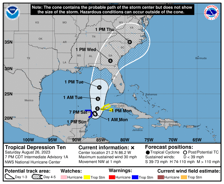
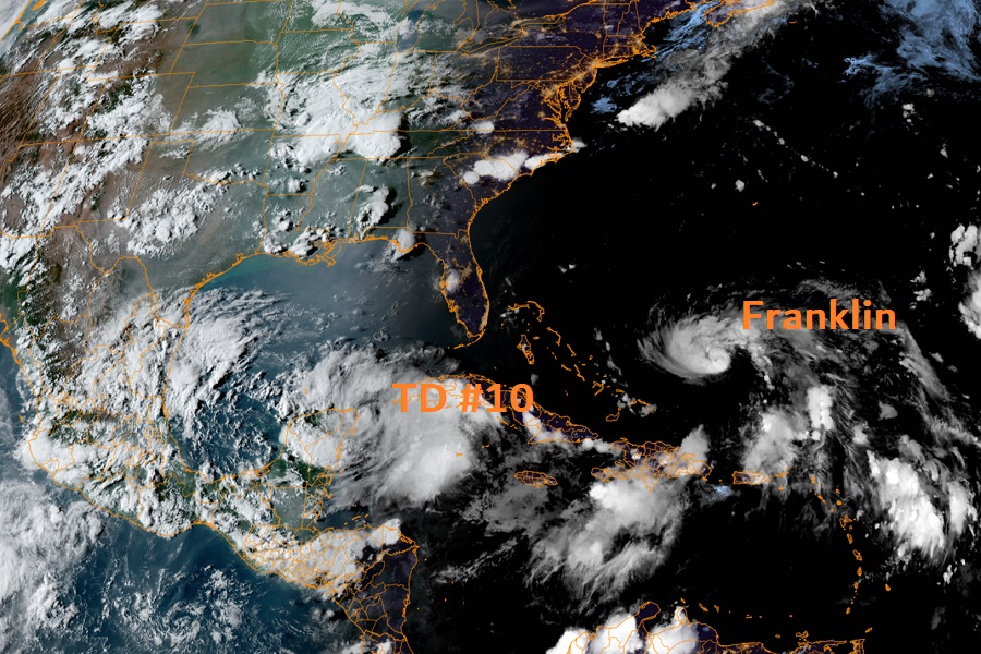
The National Hurricane Center in Miami, Florida has classified a disturbance moving into the Gulf of Mexico as a tropical depression, the 10th of the 2023 Atlantic Hurricane Season. The system, known for now as Tropical Depression #10, is forecast to become a hurricane before impacting Florida and the U.S. East Coast. When it reaches tropical storm strength on the way to becoming a hurricane, it will be named Idalia.

No Tropical Storm or Hurricane Watches or Warnings are up for the United States yet, but that could change by the end of the weekend.

Right now, Tropical Depression #10 is located about 45 miles east-northeast of Cozumel Mexico. With maximum sustained winds of 30 mph, the storm is drifting to the northwest at 1 mph. The minimum central pressure is 1005 mb or 29.68″.

According to the National Hurricane Center (NHC), the depression is nearly stationary, and little overall movement is expected through Sunday. A slow, generally northward, motion is expected to begin on Monday. On the forecast track, the center will move into the southeastern Gulf of Mexico by Monday.


Latest satellite view shows Tropical Depression #10 taking shape  while Hurricane Franklin is getting stronger.  Image: NOAA
Latest satellite view shows Tropical Depression #10 taking shape while Hurricane Franklin is getting stronger. Image: NOAA

Maximum sustained winds are near 30 mph with higher gusts now. Gradual strengthening is forecast by the NHC during the next few days, and the system is likely to become a tropical storm on Sunday. The system could then become a hurricane over the eastern Gulf of Mexico by Tuesday.

Impacts in Florida may be felt as soon as Monday evening. Impacts could be felt across Georgia by Tuesday night, with the storm moving up the southeast into South Carolina by Wednesday morning. From there, the system should accelerate up the coast.  An area of high pressure over the Great Lakes will help steer the storm east over time, but it isn’t yet known how far up the east coast the storm will be before such a turn out to sea happens.  As such, everyone from New York City south along the U.S. East Coast should closely monitor this storm over the next several days.

In Florida, forecasters are urging people to have their Hurricane Action Plan in order. By tomorrow night, it may become necessary to act on it.

Primary Sidebar

Sponsored Ad

Search

Latest News

  • USGS Reports Multiple Earthquakes Striking Iran, Including 5.1 Event
  • Volcano in Hawaii Explodes to Life, Prompting USGS to issue VOLCANO WATCH
  • Destructive Wind and Tornado Threat Today in New Jersey, Pennsylvania, Maryland, Delaware, and Virginia
  • Erick Grows Into Category 4 Hurricane, Strikes Land
  • Elevated Threat of Tornadoes Across Northeast on Thursday
  • Tropical Storm Erick Forecast to Become Strong Hurricane
  • National Hurricane Center Says Dalila is Gone But Erick Is On the Way
  • Overnight Earthquake Rocks Eastern Tennessee
About | Careers | Contact | Contests
Terms | Privacy | Ad Choices
Weatherboy is a (R) Registered Trademark of isarithm LLC, All Rights Reserved.
All content herein is Copyright by Isarithm LLC 1997-2022