• Skip to primary navigation
  • Skip to main content
  • Skip to primary sidebar

Weatherboy

Weatherboy Weather News, Maps, RADAR, Satellite, and Forecasts.

  • Local
  • Earth Science News
  • RADAR
  • Current Warnings
  • Satellite
  • Current Maps
  • Forecast Maps
  • Video

Tropical Depression #13 Forms; Likely to Become Category 3+ Hurricane Lee

by Weatherboy Team Meteorologist - September 5, 2023

This view of the Atlantic from the GOES-East weather satellite shows tropical depression #13 circled while the star illustrates where it is expected to be by Sunday morning. Sea surface temperatures on this map, with reds and oranges reflecting warmer readings while blue and green reflect colder, show conditions ripe for significant development of this system over the next several days. Image: NOAA


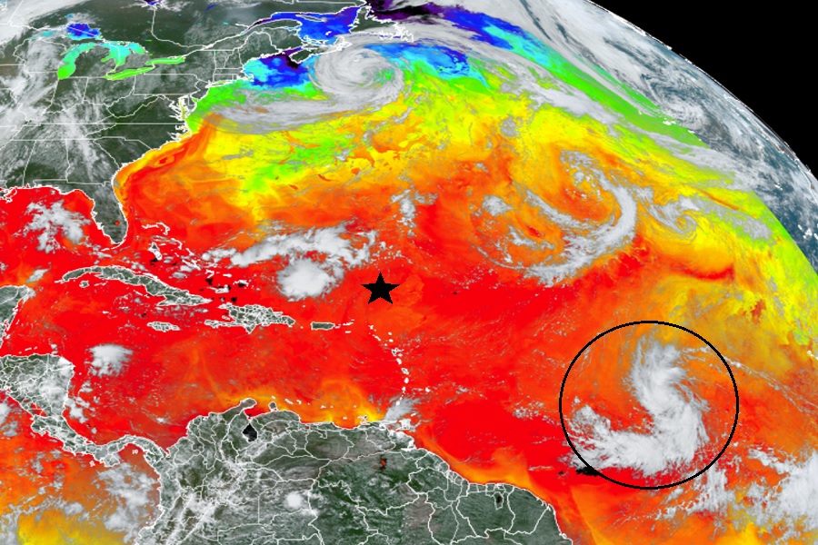
According to the National Hurricane Center (NHC) in Miami, Florida, Tropical Depression #13 has formed in the central Atlantic; over the next several days, it is forecast to intensify significantly, becoming a major category 3 hurricane or worse.

The environment around the depression appears to be conducive for strengthening. In the latest forecast discussion, NHC meteorologists say that the only obvious hindering factor is light-to-moderate northeasterly shear, which should keep the intensification rate in check in the short term. However, in two to three days, this shear is forecast to relax with an upper-level ridge building near the cyclone, and the system should be moving over record-warm waters of near 30 degrees C east of the Lesser Antilles. “These factors could support rapid intensification by the end of the week, although it too early to determine exactly when this might occur until a better-defined inner core forms,” the NHC said.  “All indications are that the depression will become a strong hurricane by the end of the forecast period.

The latest official forecast from the National Hurricane Center for what will be Major Hurricane Lee. Image: NHC


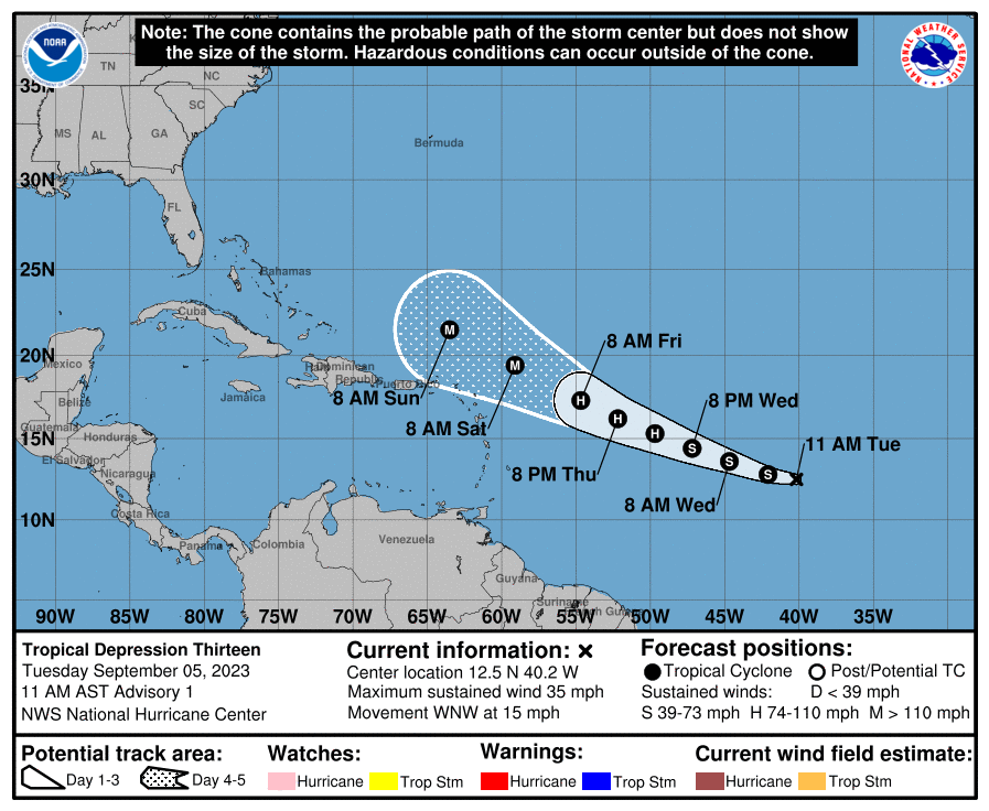
For now, the system is located 1,425 miles east of the Lesser Antilles with an estimated minimum central pressure of 1008 mb or 29.77″. The storm, with maximum sustained winds for now of 35 mph, is moving to the west-northwest at 15 mph.


The National Hurricane Center forecasts the system will strengthen to Tropical Storm Lee later today. By Wednesday night, it should reach hurricane strength, and by Saturday morning, it should become a major hurricane with winds greater than 110 mph.

Computer forecast guidance is aligned around the idea of significant intensification, with most models calling for a category 3 or 4 or greater hurricane within 5 days on the Saffir-Simpson hurricane wind scale. While confidence is high that this hurricane will become a powerful, major one, confidence isn’t as high with the system’s future track.  Some computer guidance still suggests the storm will reach the east coast of the U.S. and/or Canada with time.  For now, the National Hurricane Center’s official forecast only goes out to Sunday morning and where the storm travels beyond that is less certain.


Primary Sidebar

Sponsored Ad

Search

Latest News

  • Mid Atlantic to Become Extra Moist
  • Southeast Soaker Likely Next 72 Hours
  • Igloo Cooler Recalled Due to Amputation / Crushing Threat
  • Longtime TV Meteorologist Fired
  • Spacecraft Launched by Soviet Union in 1972 Crashed Back on Earth Today
  • Strong Tennessee Earthquake Reported by 35,000+ People
  • Updated Crash Forecast Puts Eastern U.S. on Alert from Soviet Union Spacecraft
  • Soviet Union Spacecraft Crash Zones Updated; NJ/NY/PA/MI at Increased Risk
About | Careers | Contact | Contests
Terms | Privacy | Ad Choices
Weatherboy is a (R) Registered Trademark of isarithm LLC, All Rights Reserved.
All content herein is Copyright by Isarithm LLC 1997-2022