• Skip to primary navigation
  • Skip to main content
  • Skip to primary sidebar

Weatherboy

Weatherboy Weather News, Maps, RADAR, Satellite, and Forecasts.

  • Local
  • Earth Science News
  • RADAR
  • Current Warnings
  • Satellite
  • Current Maps
  • Forecast Maps
  • Video

Tropical Depression Unlikely to Survive

by Weatherboy Team Meteorologist - July 7, 2017

Tropical Depression #4 spins about in the open Atlantic early on July 7. Image: NOAA

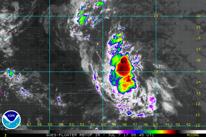
The latest satellite image of Tropical Depression #4 looks poor and it is unlikely this system will survive beyond a few days. The system has a small area of circulation that the National Hurricane Center (NHC) is calling “tenacious.” The NHC says the depression has continued to hold its own early this morning with the low-level center now having moved up into the deep convective cloud mass.


Latest official NHC forecast track for Tropical Depression #4. Map: National Hurricane Center

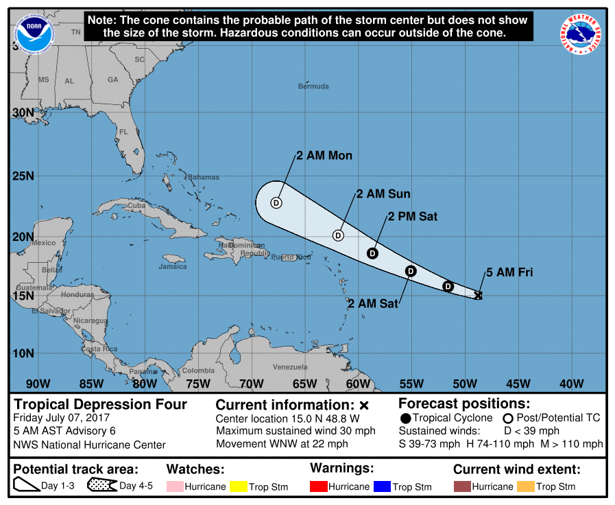
A strong low- to mid-level ridge to the north of the depression should act to steer the small cyclone generally west-northwestward until dissipation occurs in about 3-4 days. The new forecast track from the National Hurricane Center lies down the middle of the tightly clustered model suite. As the official forecast track shows, the depression is expected to retain that status for another 36 hours or so. While the vertical wind shear remains relatively low, westerly vertical wind shear is forecast to increase  which should induce gradual weakening. The small cyclone is expected to degenerate into a remnant low by 48-72 hours and dissipate by 96 hours.  The National Hurricane Center does offer caution though, saing that there is a model (UKMET) that does strengthen the system over time. Although the other global and regional models do not show regeneration at this time, they do however show similar improving upper-level wind conditions east of Florida in 5 days. For now, the official intensity forecast remains similar to the previous NHC advisory.

Even if the system dissipates, lingering moisture may enhance rainfall rates along a frontal system that’ll be on the eastern US in about a week.


Experts believe this Atlantic Hurricane Season, which runs through to the end of November, will be a busy one.  Dr. Phil Klotzbach and the experts at Colorado State University updated their seasonal outlook again on July 5, showing a much more active than normal season expected. The National Oceanic and Atmospheric Administration  (NOAA) also released their own forecast which shows this hurricane season to be likely more active than others.
Satellite images, forecast models, and the latest advisories for tropical cyclones anywhere near North America can be found on our Hurricanes & Tropical Weather section of this website.

Primary Sidebar

Sponsored Ad

Search

Latest News

  • Severe Weather Threat Returns to Mississippi Valley on Friday
  • Deadline for SBA Aid for Kauai Drought Coming Soon
  • Another Atmospheric River Event Slams into West Coast; More Epic Rain, Snow Expected
  • Anniversary of 1964 Great Alaskan “Good Friday” Earthquake and Tsunami
  • Tornado Watches, Warnings Issued as Severe Weather Impacts Louisiana, Mississippi, Alabama, & Gerogia
  • After Violent Night, Storms Shift to Ohio and Pennsylvania
  • Preliminary NTSB Report Shows Something other than Turbulence Killed Passenger on New England Flight
  • SEVERE Geomagnetic Storm Alert Issued; Massive Aurora On Display in North America
About | Careers | Contact | Contests
Terms | Privacy | Ad Choices
Weatherboy is a (R) Registered Trademark of isarithm LLC, All Rights Reserved.
All content herein is Copyright by Isarithm LLC 1997-2022