Tropical Storm Beta has formed in the Gulf of Mexico and the National Hurricane Center expects it to strengthen into a hurricane this weekend.
An evolution of Tropical Depression #22, Beta has shattered many records in the Atlantic Hurricane Basin today, joining Subtropical Storm Alpha and Tropical Storm Wilfred that formed earlier today. The only other time on record that three named storms formed on the same day was August 15, 1893. Beta is the 23rd name storm of the 2020 Atlantic Hurricane Season and the 10th of just this month. On average, the Atlantic only has 8 named storms by this date.
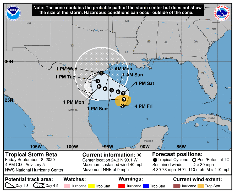
As of the latest update from the National Hurricane Center, Beta was located about 335 miles east-northeast of Tampico, Mexico and was about 280 miles east-southeast of the Mouth of the Rio Grande. With maximum sustained winds of 40 mph, Beta was moving to the north-northeast at 9 mph.
There are no warnings up for Beta yet but the National Hurricane Center says that could change soon. Storm Surge and Tropical Storm or Hurricane Watches will likely be required for portions of the western Gulf coast later tonight or tomorrow.
While Beta is moving toward the north-northeast near 9 mph now, and this general motion is expected through Saturday, a slow westward motion is forecast to begin late Saturday or Saturday night, and this motion will likely continue into early next week. On the forecast track, the center of Beta will approach western coast of the Gulf of Mexico Sunday night and Monday. As it drifts about, additional slow strengthening is expected through the weekend, and Beta could be near hurricane strength Sunday or Sunday night.
Swells are expected to increase and reach the coast of Texas and the Gulf Coast of Mexico over the weekend, generated by a combination of Beta and a cold front entering the northern Gulf of Mexico. These swells are likely to cause life-threatening surf and rip current conditions. Even experienced swimmers and surfers should avoid the Gulf of Mexico until calm waters return.
Whether Beta impacts the U.S. as a tropical storm or hurricane, it is likely extremely heavy rain will soak the coast. The National Weather Service Weather Prediction Center believes more than a foot of rain will fall along the entire Texas coast in the coming days, with even more rain likely where the center of the storm comes ashore. People in Texas should prepare for a significant, multi-day flood event.
